Mine Index Number: 3663
| Company Name:
|
United States Fuel Company
|
| Mine Name:
|
Kelly No. 3 Mine
|
| Start Date:
|
1896
|
End Date:
|
March 1921
|
| Type of Mine:
|
Underground
|
| Total acres shown:
|
1,152
|
| Acres after map date:
|
|
General Area of mining acres shown:
|
|
|
The boundaries between the Kelly mines (No.s 1 through 5 and 46 and 47, mine index numbers 3731, 3729, 3663, 3660, 3740, 3664 and 3661) cannot be distinguished with any accuracy. The total area for these Kelly mines (5,300 acres) is in line with production of all the Kelly mines.
|
Shaft, Slope, Drift or Tipple Location(s)
| Type
|
County
|
Township-Range
|
Section
|
Part Section
|
| Main shaft
|
Vermilion
|
18N 11W
|
7
|
NW SW NE No air shafts were shown in this portion of the Kelly mines complex. Interconnection with other Kelly mines underground may have provided air and escapeways to satisfy regulations of the times.
|
Geology
| Herrin
|
189-195
|
|
|
5.5-6.0
|
RP
|
Geological Problems Reported
Production
| Company
|
Mine Name
|
Date
|
Production (tons)
|
|
|
|
|
|
| Total Production: 5,747,250
|
Production Notes
Coal Report production (if available)
Sources of Data
| ISGS map library, 4103.V4 i5.1-135 A final map is available at the Vermilion County Recorder’s Office (cabinet 03899, drawer 2). The map is too large to trace.
|
7-1-1947
|
1:42240
|
1:42240
|
Secondary source
|
Annotated Bibliography (Data source - brief description of information)
| Coal Reports - Production, ownership, years of operation, mine type, mining method.
|
| Directory of Illinois Coal Mines (Vermilion County) - Mine names, mine index, ownership, years of operation.
|
| Mine notes (Vermilion County) - Mine type, shaft location, seam, depth, thickness.
|
| ISGS map library, 4103.V4 i5.1-135, property map of U.S. Coal & Coke Company - Shaft locations, mine outline, mining method.
|
Mine Notes
Mine Images
Map library: 4103.V4 i5.1-135
Map Date: 7-1-1947
Coal Co.: United States Fuel Company
Mine Name: Kelly No. 4 Mine
Full Res Download
Photographs
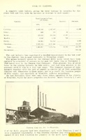
Caption: Pond caused by subsidence at Westville, Vermilion County, where 6 feet of coal was removed by room-and-pillar mining at a depth of 210 feet. Levels at surface show maximum depth of sag to by 4.7 feet.
Credit: Illinois State Geological Survey
Date: Pre-1914
Publication: Fig. 30 Cooperative Bulletin 17 – Subsidence in Illinois
Library No.: M-813
Credit: Illinois State Geological Survey
Library No.: M-932
Caption: South of shaft, 3 feet deep
Credit: Illinois State Geological Survey
Library No.: M-933
Caption: Kellyville No. 3 Near Electric mine Danville District. 8 foot diameter, 3 feet deep.
Credit: Illinois State Geological Survey
Library No.: M-934
Caption: Ash filled road washed away.
Credit: Illinois State Geological Survey
Library No.: M-938
Credit: Illinois State Geological Survey