2096: Difference between revisions
Alan.Myers (talk | contribs) No edit summary |
No edit summary |
||
| Line 1: | Line 1: | ||
{{Sidebar Info Query}} | {{Sidebar Info Query}} | ||
{{Header | {{Header | ||
|checked= | |checked=Checked OK | ||
|unlocated=No | |unlocated=No | ||
|shown_on_map=Yes | |shown_on_map=Yes | ||
| Line 8: | Line 8: | ||
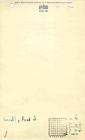
|Mine Name Header=Lovell Mine | |Mine Name Header=Lovell Mine | ||
|mine_type=Underground | |mine_type=Underground | ||
|mined-out-area=4 | |mined-out-area=4 {{#info: The area shown on the accompanying map is smaller than expected for the reported production. Production indicates 9 acres were mined before the map date. |note}} | ||
|after_map=6 | |||
|indicated=Yes | |indicated=Yes | ||
|county1=Fulton | |county1=Fulton | ||
|quad1=Ipava | |quad1=Ipava | ||
|city1=Ipava | |||
|year-start=1919 | |year-start=1919 | ||
|year-end=1933 | |year-end=1933 | ||
Latest revision as of 16:06, July 26, 2023
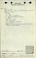
Mine Index Number: 2096
| Company Name: | Fred J. Lovell | ||
|---|---|---|---|
| Mine Name: | Lovell Mine | ||
| Start Date: | 1919 | End Date: | 1933 |
| Type of Mine: | Underground | ||
| Total acres shown: | 4 The area shown on the accompanying map is smaller than expected for the reported production. Production indicates 9 acres were mined before the map date. | ||
| Production Indicated Acres: | 6 | General Area of mining acres shown: | |
Shaft, Slope, Drift or Tipple Location(s)
| Type | County | Township-Range | Section | Part Section |
|---|
| Shaft | Fulton | 4N 2E | 6 | NW SE SE |
| Air shaft | Fulton | 4N 2E | 6 | NE SE SE |
Geology
| Thickness (ft) | |||||
|---|---|---|---|---|---|
| Seam | Depth (ft) | Min | Max | Ave | Mining Method |
| Springfield | 19-38 | 5.5-6.0 | MRP |
Geological Problems Reported
The coal extended about 500 feet west, north to the highway, and about 3/8 of a mile to the south. The coal became unworkable in all directions on account of poor roof. The source map shows caved sections in northern and eastern entries.
Production
| Company | Mine Name | Date | Production (tons) |
| Fred J. Lovell | Lovell | 1919-1931 | 46,540 |
| Fred J. Lovell | Lovell | 1931-1933 | 27,815 Production after map date |
| Total Production: 74,355 | |||
Production Notes
Coal Report production (if available)
Sources of Data
| Source Map | Map Date | Original Scale | Digitized Scale | Map Type |
| Company, 4103.F8 i5.1-20 | 6-24-1931 | 1:600 | 1:600 | Not final |
Annotated Bibliography (Data source - brief description of information)
| Coal Reports - Production, ownership, years of operation. |
| Directory of Illinois Coal Mines (Fulton County) - Mine names, mine index, ownership, years of operation. |
| Mine notes (Fulton County) - Mine type, shaft location, seam, depth, thickness. |
| ISGS field notes (Fulton County) - Mine type, shaft location. |
| Company map, ISGS map library, 4103.F8 i5.1-20 - Shaft locations, mine outline, mining method, geologic problems. |
Mine Notes
Mine Images
![[[:Lovell|Lovell]]](https://go.illinois.edu/ILMImages/fulton/thumbnails/m2096_geo_th.jpg)
Photographs