Mine Index Number: 3881
| Company Name:
|
Taylor-English Coal Company
|
| Mine Name:
|
Taylor-English No. 1 Mine
|
| Start Date:
|
1895
|
End Date:
|
January 1919
|
| Type of Mine:
|
Underground
|
| Total acres shown:
|
101 in Danville, 476 in Herrin
|
| Acres after map date:
|
20
|
General Area of mining acres shown:
|
|
|
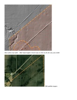
The source maps are poor, and the area shown is about 70 acres larger than expected. The area shown for the Herrin Coal may be a property outline rather than the extent of mining. However, a general area of mining has been added as LiDAR images indicate mining may have taken place north of the mine outline.
|
Shaft, Slope, Drift or Tipple Location(s)
| Type
|
County
|
Township-Range
|
Section
|
Part Section
|
| Main shaft
|
Vermilion
|
19N 12W
|
35
|
NW SW NW
|
| Air shaft
|
Vermilion
|
19N 12W
|
34
|
SE SE NE
|
Geology
| Danville
|
135-168
|
|
|
5.5-6.0
|
RP
|
Geological Problems Reported
Production
| Company
|
Mine Name
|
Date
|
Production (tons)
|
|
|
|
|
|
| Total Production: 2,090,843
|
Production Notes
Coal Report production (if available)
Sources of Data
| Federal Land Bank Report
|
1-1934
|
1:105000
|
1:105000
|
Secondary source
|
| USGS Folio 67
|
12-1900
|
1:62500
|
1:62500
|
Secondary source
|
| Coal Section files, 1-24-31j
|
Undated
|
1:62500
|
1:62500
|
Secondary source
|
| LiDAR
|
2012
|
|
|
Secondary source
|
Annotated Bibliography (Data source - brief description of information)
| Coal Reports - Production, ownership, years of operation, depth, thickness, mining method.
|
| Directory of Illinois Coal Mines (Vermilion County) - Mine names, mine index, ownership, years of operation.
|
| Mine notes (Vermilion County) - Mine type, shaft location, seams.
|
| Federal Land Bank Report (Vermilion County) - Mine outline (Danville Coal).
|
| USGS Folio 67, Danville (15-minute) Quadrangle - Air shaft location (Danville Coal).
|
| Coal Section files, 1-24-31j, Herrin Coal Thickness - Mine outline, shaft location (Herrin Coal).
|
| LiDAR Digital Terrain Model, Vermilion County - Indications of mining.
|
Mine Notes
Mine Images
USGS composite map:
Map Date: 12-1900
Coal Co.: Taylor-English Coal Company
Mine Name: Taylor-English No. 2 Mine
Full Res Download
Federal Land Bank Report:
Map Date: 1-1934
Coal Co.: William Hodges
Mine Name: Hodges Mine
Full Res Download
Coal Section composite: 1-24-31j
Map Date: Undated
Coal Co.: Taylor-English Coal Company
Mine Name: Taylor-English No. 1 Mine
Full Res Download
Photographs