Mine Index Number: 0810
| Company Name:
|
Groveland Coal Mining Company
|
| Mine Name:
|
Groveland No. 1 Mine
|
| Start Date:
|
1900
|
End Date:
|
April 1921
|
| Type of Mine:
|
Underground
|
| Total acres shown:
|
1,207
|
| Acres after map date:
|
|
General Area of mining acres shown:
|
|
|
The boundary between Crescent No. 2 (mine index 0108) and Groveland No. 1 Mine (mine index 0810) could not be discerned. The outline shown on the accompanying map includes both mines.
|
Shaft, Slope, Drift or Tipple Location(s)
| Type
|
County
|
Township-Range
|
Section
|
Part Section
|
| Main shaft
|
Tazewell
|
25N 4W
|
7
|
NW SW NW
|
| Air shaft
|
Tazewell
|
25N 4W
|
7
|
NW SW NW
|
| Air shaft
|
Tazewell
|
25N 4W
|
7
|
SE NE SW
|
Geology
| Springfield
|
85-96
|
3.0
|
4.67
|
4.3
|
RPP
|
Geological Problems Reported
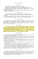
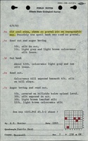
A sandstone paleochannel was present above the coal, sometimes cutting out the limestone and massive gray shale above the coal. This sandstone held considerable water, which worked its way into the shale. The roof was practically impossible to keep up. After the shale came down, generally everything below the sandstone would eventually come down, sometimes up to 20 feet of material. The shaley limestone was only 2 to 8 inches thick, and had no supportive strength. The dark gray shale also had no supportive strength and fell readily. There was some black shale above the coal, and this contained large concretions, some over 1 foot thick and 2 feet long. The coal was very uniform in thickness except near horsebacks or rolls. Bedded impurities included thin streaks of clay and mother coal, and, on the eastern side of the mine, bands of brown pyrite that were 1.5 inches thick and up to 5 feet long. The eastern side of the mine had very poor conditions, including numerous horsebacks and blind slips in the coal and roof rock, which appeared to be horsebacks with no clay filling. The roof was very poor near these blind slips. The underclay floor heaved when wet and held water so that it was difficult to drain.
Production
| Company
|
Mine Name
|
Date
|
Production (tons)
|
|
|
|
|
|
| Total Production: 1,799,318
|
Production Notes
Coal Report production (if available)
Sources of Data
| Company, 4103.T3 i5.1-2
|
6-30-1924
|
1:2400
|
1:2400
|
Final
|
| Microfilm, document 352848
|
6-1-1928
|
1:2400
|
1:4468
|
Final
|
| Microfilm, document 352859
|
7-12-1928
|
1:2400
|
1:4303
|
Final
|
Annotated Bibliography (Data source - brief description of information)
| Coal Reports - Production, ownership, years of operation.
|
| Directory of Illinois Coal Mines (Tazewell County) - Mine names, mine index, ownership, years of operation.
|
| Mine notes (Tazewell County) - Mine type, shaft location, seam, depth, thickness, geologic problems.
|
| Company map, ISGS map library, 4103.T3 i5.1-2 - Shaft locations, mine outline (western), mining method.
|
| Microfilm map, document 352848, reel 03140, frames 476-479 - Shaft locations, mine outline, mining method.
|
| Microfilm map, document 352859, reel 03140, frames 480-483 - Mine outline (southern & eastern).
|
Mine Notes
Mine Images
Photographs
![[[:Crescent No. 2|Crescent No. 2]]](https://wikiimage.isgs.illinois.edu/ilmines/tazewell/thumbnails/m0108_m810_MSHA_670_03_th.jpg)
![[[:Crescent No. 2|Crescent No. 2]], [[:Crescent No. 1|Crescent No. 1]]](https://wikiimage.isgs.illinois.edu/ilmines/tazewell/thumbnails/m0108_m0810_PB_902_03_th.jpg)