0879: Difference between revisions
No edit summary |
Alan.Myers (talk | contribs) No edit summary |
||
| (One intermediate revision by the same user not shown) | |||
| Line 1: | Line 1: | ||
{{Sidebar Info Query}} | {{Sidebar Info Query}} | ||
{{Header | {{Header | ||
|checked=1st Entry | |||
|unlocated=No | |unlocated=No | ||
|shown_on_map=Yes | |shown_on_map=Yes | ||
| Line 71: | Line 72: | ||
|Date=1968-1996 | |Date=1968-1996 | ||
|Production=57,779,383 | |Production=57,779,383 | ||
|Sum=No | |||
| | |||
}} | }} | ||
{{Production | {{Production | ||
|Production=57,779,383 | |Production=57,779,383 | ||
|Sum=Yes | |||
}} | }} | ||
===Production Notes=== | ===Production Notes=== | ||
| Line 113: | Line 113: | ||
{{Photo Query}} | {{Photo Query}} | ||
{{Editwithform | {{Editwithform}} | ||
{{#set: Company=British Petroleum}} | {{#set: Company=British Petroleum}} | ||
{{#set: Company=Zeigler Coal Holding Company}} | {{#set: Company=Zeigler Coal Holding Company}} | ||
Latest revision as of 16:17, June 2, 2022
Mine Index Number: 0879
| Company Name: | Old Ben Coal Corporation | ||
|---|---|---|---|
| Mine Name: | Old Ben No. 26 Mine | ||
| Start Date: | 1968 | End Date: | 1996 |
| Type of Mine: | Underground | ||
| Total acres shown: | 7,165 | ||
| Acres after map date: | General Area of mining acres shown: | ||
Shaft, Slope, Drift or Tipple Location(s)
| Type | County | Township-Range | Section | Part Section |
|---|
| Hoist shaft | Franklin | 5S 2E | 20 | NE NE |
| Man & material shaft | Franklin | 5S 2E | 20 | SE NE |
| C portal & D shaft | Franklin | 5S 2E | 32 | NE NE |
| E & F shaft | Franklin | 5S 2E | 30 | SW NW |
Geology
| Thickness (ft) | |||||
|---|---|---|---|---|---|
| Seam | Depth (ft) | Min | Max | Ave | Mining Method |
| Herrin | 640-651 | 8.0-8.8 | RPP, LW, RP, HERThe mining method is recorded as RPP from 1968 to 1978, and afterwards as LW & RP. The source map shows areas where pillars were removed as mining ended in different areas. |
Geological Problems Reported
A fault system was encountered in the East North mains and the East South mains, which had up to 8 feet of displacement. The main fault zone was about 15 feet wide, with as much as 55 feet of displacement. Oil seeped in along the fault. The roof over most of the mine was Energy Shale, often massive and very silty. Some large (up to 12 inches long) limestone nodules were noted in the Energy Shale. Generally 6 to 10 inches of top coal was left to support and protect the Energy Shale roof. The Anna Shale was the immediate roof over the coal in some rare cases. The coal seam contained rolls 3 to 4 feet wide and smaller. Concretions, small and elongated, occurred in places. Erosional channels were also present. Minor floor heave was seen in several places, along both entries and crosscuts (no preferred orientation).
Production
| Company | Mine Name | Date | Production (tons) |
| Old Ben Coal Corporation owned by British Petroleum in the 1980s; bought by Zeigler Coal Holding Company in July 1990 | Old Ben No. 26 | 1968-1996 | 57,779,383 |
| Total Production: 57,779,383 | |||
Production Notes
Coal Report production (if available)
Sources of Data
| Source Map | Map Date | Original Scale | Digitized Scale | Map Type |
| Company map | 12-31-1996 | 1:4800 | 1:4800 | Final |
Annotated Bibliography (Data source - brief description of information)
| Coal Reports - Production, ownership, years of operation, seam, depth, thickness, mining method. |
| Directory of Illinois Coal Mines (Franklin County) - Mine names, mine index, ownership, years of operation. |
| Mine notes (Franklin County) - Mine type, shaft location, thickness, geologic problems. |
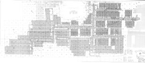
| Company map, ISGS Coal Section files (digital) - Shaft locations, mine outline, mining method. |
Mine Notes
Mine Images
Photographs


