Sesser Quadrangle
Mining in the Sesser Quadrangle
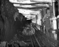
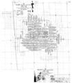
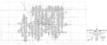
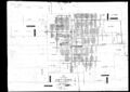
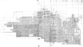
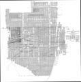
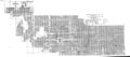
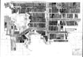
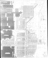
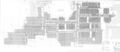
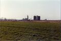
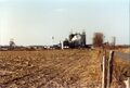
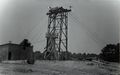
The earliest mining in the Sesser Quadrangle was the Old Ben No. 16 Mine (mine index 0050) in 1905. Mining probably began so late here because of the coal depth; the Herrin Coal was generally over 600 feet deep. The last mining here was the Rend Lake Mine (mine index 0877), which ceased production in 2002. The Herrin Coal was quite thick in this area, with average thickness between 7 and 9 feet. The coal was sometimes split. The accompanying map shows that very little area is left unmined, so the split coal apparently affected only small local areas. The seam bottom undulated, and rolls were common but apparently only affected local areas. The roof was commonly gray shale, and roof problems were noted in most of the mines. Top coal was generally left to support the roof and protect the shale from moisture in the ventilating air, which exacerbated the propensity of the shale to come down. The depth of the coal was probably a factor in forcing gas out of the seam. At least 6 explosions were noted, with a total of 21 fatalities. Some faults, associated with the Rend Lake Fault System, were noted in the mines, but displacement was generally less than 10 feet and did not affect large areas.
Map and Directory PDF Download
Coal Mines In Illinois Sesser Quadrangle
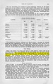
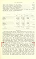
Mines that Appear on the Sesser Quadrangle
Unlocated Mines
Franklin County
Jefferson County
Perry County
Pages in category "Sesser Quadrangle"
The following 10 pages are in this category, out of 10 total.
Media in category "Sesser Quadrangle"
The following 40 files are in this category, out of 40 total.
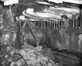
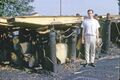 1960s Old Ben 21 Rheinstahl-Wanheim 4 leg chocks MI 863.jpg 3,000 × 1,997; 209 KB
 1964 Rheinstahl-Wanheim 6 leg Chocks Old Ben 21 used Face 3 2.jpg 2,530 × 1,776; 515 KB
 1964 Rheinstahl-Wanheim 6 leg Chocks Old Ben 21 used Face 3.jpg 2,530 × 1,686; 545 KB
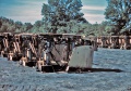
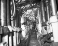
 1969 Jun-1970 Apr Old Ben 21 Face 6 Gullick Chocks 1.jpg 2,863 × 2,291; 575 KB
 1969 Jun-1970 Apr Old Ben 21 Face 6 Gullick Chocks 2.jpg 3,000 × 2,414; 511 KB
 1969 Jun-1970 Apr Old Ben 21 Face 6 Gullick Chocks 3.jpg 3,000 × 2,411; 471 KB
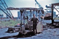
 1969 Jun-1970 Apr Old Ben 21 Joy-Gullick 600 ton Chocks used on Face 6 4.jpg 3,000 × 2,005; 220 KB
 1969 Jun-1970 Apr Old Ben 21 Joy-Gullick 600 ton Chocks used on Face 6.jpg 3,000 × 2,027; 248 KB
 M0050 coalreport 1906.pdf 779 × 1,237; 397 KB
 M0050 coalreport 1907.pdf 587 × 966, 2 pages; 161 KB
 M0050.jpg 2,963 × 3,390; 2.4 MB
 M0056 coalreport 1907.pdf 587 × 966; 116 KB
 M0056 coalreport 1909.pdf 716 × 1,193, 2 pages; 760 KB
 M0056 minenotes.pdf 739 × 1,193, 18 pages; 4.76 MB
 M0056.jpg 3,390 × 1,436; 1.12 MB
 M0134 coalreport 1917.pdf 602 × 991; 88 KB
 M0134 minenotes.pdf 739 × 1,193, 31 pages; 8.24 MB
 M0134.jpg 3,390 × 2,403; 1.89 MB
 M0136 coalreport 1917.pdf 602 × 991, 2 pages; 159 KB
 M0136 coalreport 1930.pdf 637 × 966; 70 KB
 M0136 minenotes.pdf 739 × 1,193, 36 pages; 9.61 MB
 M0136.jpg 3,390 × 1,957; 2.14 MB
 M0665 coalreport 1912.pdf 795 × 1,241, 4 pages; 13.25 MB
 M0665 minenotes.pdf 739 × 1,193, 15 pages; 4.12 MB
 M0665wrp.jpg 3,371 × 3,390; 4.25 MB
 M0666 coalreport 1913p246.pdf 793 × 1,187; 1.46 MB
 M0666 coalreport 1918expl.pdf 883 × 1,295, 7 pages; 264 KB
 M0666 minenotes.pdf 739 × 1,193, 28 pages; 7.77 MB
 M0666.jpg 3,390 × 1,494; 1.9 MB
 M0863 minenotes.pdf 739 × 1,193, 182 pages; 22.63 MB
 M0863wrp.jpg 3,390 × 2,317; 3.39 MB
 M0866 minenotes.pdf 739 × 1,193, 26 pages; 6.65 MB
 M0866.jpg 3,106 × 3,800; 4.87 MB
 M0877 minenotes.pdf 731 × 1,202, 116 pages; 33.33 MB
 M0879 minenotes.pdf 739 × 1,193, 83 pages; 27.61 MB
 M0879wrp.jpg 3,390 × 1,473; 1.69 MB
 Mn act jackson 01.jpg 3,012 × 2,034; 1.7 MB
 Mn act jackson 02.jpg 3,016 × 2,028; 1.99 MB
 Mn act jackson 03.jpg 2,837 × 1,782; 908 KB
 Mn act jackson 04.jpg 2,850 × 1,794; 944 KB


