3258: Difference between revisions
No edit summary |
Alan.Myers (talk | contribs) No edit summary |
||
| Line 19: | Line 19: | ||
|Latitude=37.77341649 | |Latitude=37.77341649 | ||
|Longitude=-88.6611859 | |Longitude=-88.6611859 | ||
|Zoom= | |Zoom=15 | ||
}} | }} | ||
==Shaft, Slope, Drift or Tipple Location(s)== | ==Shaft, Slope, Drift or Tipple Location(s)== | ||
Latest revision as of 09:38, May 2, 2024
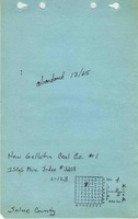
Mine Index Number: 3258
| Company Name: | New Gallatin Coal Company | ||
|---|---|---|---|
| Mine Name: | New Gallatin No. 1 Mine | ||
| Start Date: | 1964 | End Date: | December 1965 |
| Type of Mine: | Surface | ||
| Total acres shown: | 38 | ||
| Production Indicated Acres: | 17 | General Area of mining acres shown: | |
|
The large area shown may include some portions of the Delta Mine (mine index 0702) or other unlocated mines at the back of this report, or may be an outline of disturbed, but unmined, land. | |||
Shaft, Slope, Drift or Tipple Location(s)
| Type | County | Township-Range | Section | Part Section |
|---|
| Pit | Saline | 9S 5E | 4 | NW NE |
Geology
| Thickness (ft) | |||||
|---|---|---|---|---|---|
| Seam | Depth (ft) | Min | Max | Ave | Mining Method |
| Herrin | 60 | 5.0 | Surface |
Geological Problems Reported
Production
| Company | Mine Name | Date | Production (tons) |
| New Gallatin Coal Company | New Gallatin No. 1 | 1964-1965 | 137,724 |
| Total Production: 137,724 | |||
Production Notes
Coal Report production (if available)
Sources of Data
| Source Map | Map Date | Original Scale | Digitized Scale | Map Type |
| Coal Section files | 1965 | 1:7680 | 1:7680 | Secondary source |
Annotated Bibliography (Data source - brief description of information)
| Coal Reports - Production, ownership, years of operation, depth, thickness, mining method. |
| Directory of Illinois Coal Mines (Saline County) - Mine names, mine index, ownership, years of operation. |
| Mine notes (Saline County) - Mine type, pit location, seam. |
| Coal Section files (strip mine updates) - Mine location, mine outline. |
Mine Notes
Mine Images
![[[:New Gallatin No. 1|New Gallatin No. 1]]](https://go.illinois.edu/ILMImages/saline/thumbnails/7a-02-07_geo_th.jpg)
Photographs