Category:Pittsburg-Quadrangle: Difference between revisions
Alan.Myers (talk | contribs) (Created page with "{{County-Page}}") |
Alan.Myers (talk | contribs) No edit summary |
||
| (One intermediate revision by the same user not shown) | |||
| Line 1: | Line 1: | ||
{{County- | __NOTOC__ | ||
==Mining in the Pittsburg Quadrangle== | |||
Mines extending into the Pittsburg Quadrangle from the Johnson City Quadrangle to the west opened in | |||
1907 and 1908. Most of the mining here began later, around 1920. The coal was not so thick here as in | |||
the large mines on the West Frankfort Quadrangle to the northwest. | |||
The Herrin Coal is the major resource, ranging from just over 5 feet up to 9 feet thick. Limestone was | |||
found immediately above the coal in some areas, and this made a good roof. This quadrangle | |||
encompasses an area where a gray shale above the coal was of variable thickness. Where the gray shale | |||
was thick or very thin, it held up fairly well. However, where the gray shale was of intermediate or | |||
changing thickness, the roof fell readily. Several mines noted slips in the shale. These often occurred | |||
where the shale changed thickness greatly over short distance. This transitional roof facies is noted for its | |||
instability (see Treworgy and others, 2000, ''Availability of the Herrin Coal for Mining in Illinois''). Many of | |||
the mines had much water, which exacerbated some roof problems and floor heaving. Faults related to the | |||
Cottage Grove Fault System were noted in some mines, particularly the Orient No. 4 Mine (mine index | |||
[[0688]]) and the Zeigler No. 4 Mine (mine index [[0662]]). | |||
Most of the mines in the Pittsburg Quadrangle operated for 20 to 30 years, however, so these geological | |||
problems must not have been genuine hindrances to mining and did not prohibitively increase the expense | |||
of mining. The Pittsburg Quadrangle is also at the eastern edge of the thick, low-sulfur coal deposits of | |||
the “Quality Circle”. These geological factors all controlled the pattern of mining over the quadrangle, | |||
where the northeastern one-third is essentially unmined. | |||
==Map and Directory PDF Download== | |||
[https://wikiimage.isgs.illinois.edu/ilmines/webfiles/topo-mines/Pittsburg.pdf Coal Mines In Illinois Pittsburg Quadrangle]</br> | |||
==Mines that Appear on the Pittsburg Quadrangle== | |||
{{#css: | |||
#mw-subcategories {display: none} | |||
#mw-pages {display: none} | |||
#mw-category-media {display: none} | |||
}} | |||
{{#ask:[[Category:Pittsburg-Quadrangle]] | |||
[[:+]] | |||
[[Unlocated::No]] | |||
|?combined = Coal Company, Mine Name | |||
|?County | |||
|format=datatables|limit=1500|link=all|sort=Mine Index|order=asc|headers=plain|mainlabel=Mine Index|searchlabel=... further results|class=sortable wikitable smwtable|sep=<br>|Default='''Mines for this quadrangle have not been entered into Ilmines-Wiki see download above for more information'''}} | |||
==Unlocated Mines== | |||
===Franklin County=== | |||
{{#ask:[[Category:Franklin-County]] | |||
[[:+]] | |||
[[Unlocated::Yes]] | |||
|?combined = Coal Company, Mine Name | |||
|?City | |||
|format=datatables|limit=1500|link=all|sort=Mine Index|order=asc|headers=plain|mainlabel=Mine Index|searchlabel=... further results|default=There are no known Unlocated mines in this county |class=sortable wikitable smwtable|sep=<br>}} | |||
===Williamson County=== | |||
{{#ask:[[Category:Williamson-County]] | |||
[[:+]] | |||
[[Unlocated::Yes]] | |||
|?combined = Coal Company, Mine Name | |||
|?City | |||
|format=datatables|limit=1500|link=all|sort=Mine Index|order=asc|headers=plain|mainlabel=Mine Index|searchlabel=... further results|default=There are no known Unlocated mines in this county |class=sortable wikitable smwtable|sep=<br>}} | |||
{{DISPLAYTITLE:Pittsburg Quadrangle}} | |||
Latest revision as of 09:30, October 28, 2022
Mining in the Pittsburg Quadrangle
Mines extending into the Pittsburg Quadrangle from the Johnson City Quadrangle to the west opened in 1907 and 1908. Most of the mining here began later, around 1920. The coal was not so thick here as in the large mines on the West Frankfort Quadrangle to the northwest.
The Herrin Coal is the major resource, ranging from just over 5 feet up to 9 feet thick. Limestone was found immediately above the coal in some areas, and this made a good roof. This quadrangle encompasses an area where a gray shale above the coal was of variable thickness. Where the gray shale was thick or very thin, it held up fairly well. However, where the gray shale was of intermediate or changing thickness, the roof fell readily. Several mines noted slips in the shale. These often occurred where the shale changed thickness greatly over short distance. This transitional roof facies is noted for its instability (see Treworgy and others, 2000, Availability of the Herrin Coal for Mining in Illinois). Many of the mines had much water, which exacerbated some roof problems and floor heaving. Faults related to the Cottage Grove Fault System were noted in some mines, particularly the Orient No. 4 Mine (mine index 0688) and the Zeigler No. 4 Mine (mine index 0662).
Most of the mines in the Pittsburg Quadrangle operated for 20 to 30 years, however, so these geological problems must not have been genuine hindrances to mining and did not prohibitively increase the expense of mining. The Pittsburg Quadrangle is also at the eastern edge of the thick, low-sulfur coal deposits of the “Quality Circle”. These geological factors all controlled the pattern of mining over the quadrangle, where the northeastern one-third is essentially unmined.
Map and Directory PDF Download
Coal Mines In Illinois Pittsburg Quadrangle
Mines that Appear on the Pittsburg Quadrangle
Unlocated Mines
Franklin County
Williamson County
Pages in category "Pittsburg-Quadrangle"
The following 45 pages are in this category, out of 45 total.
3
6
M
- FileList:M0168
- FileList:M0169
- FileList:M0321mrg
- FileList:M0423 IL 1524
- FileList:M0662 il 798 03
- FileList:M0688a
- FileList:M0702.jpg
- FileList:M0816mrg
- FileList:M0911
- FileList:M0911 IL 793 08
- FileList:M0962 ms 15
- FileList:M0987a
- FileList:M1039 2019
- FileList:M1039 2020
- FileList:M1039 2021
- FileList:M1039 2022
- FileList:M1039 2024
- FileList:M4065
- FileList:M6792
- FileList:Msha 492 01 geo
Media in category "Pittsburg-Quadrangle"
The following 16 files are in this category, out of 16 total.
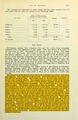 M0152 coalreport1908 p371.pdf 629 × 970; 117 KB
 M0152 minenotes.pdf 733 × 1,162, 25 pages; 4.62 MB
 M0168 minenotes.pdf 727 × 1,166, 19 pages; 4.32 MB
 M0321 coalreport1908 p372.pdf 629 × 970; 107 KB
 M0321 coalreport1917 p275.pdf 602 × 991; 96 KB
 M0321 minenotes.pdf 733 × 1,162, 10 pages; 1.88 MB
 M0423 minenotes.pdf 725 × 1,160, 13 pages; 2.33 MB
 M0448 coalreport 1913p246.pdf 793 × 1,187; 1.46 MB
 M0448 minenotes.pdf 733 × 1,202, 19 pages; 5.39 MB
 M0662 minenotes.pdf 731 × 1,162, 147 pages; 28.89 MB
 M0702 minenotes.pdf 725 × 1,156, 126 pages; 33.42 MB
 M0816 coalreport1907 p350.pdf 587 × 966; 130 KB
 M0816 minenotes.pdf 733 × 1,162, 23 pages; 3.99 MB
 M0987 minenotes.pdf 725 × 1,160, 14 pages; 2.56 MB
 M3669 minenotes.pdf 725 × 1,160, 3 pages; 513 KB
 M4065 minenotes.pdf 725 × 1,160, 8 pages; 1.42 MB