Mine Index Number: 0021
| Company Name:
|
Assumption Coal and Mining Company
|
| Mine Name:
|
Assumption Mine
|
| Start Date:
|
1889
|
End Date:
|
1928
|
| Type of Mine:
|
Underground
|
| Total acres shown:
|
283
|
| Acres after map date:
|
12
|
General Area of mining acres shown:
|
|
|
|
Shaft, Slope, Drift or Tipple Location(s)
| Type
|
County
|
Township-Range
|
Section
|
Part Section
|
| Main shaft
|
Christian
|
12N 1E
|
2
|
NE NW SE
|
| Air shaft
|
Christian
|
12N 1E
|
2
|
SE NW SE
|
Geology
| Assumption At times an upper vein was mined. The interval between the two seams varied from 2 to 25 feet. The upper seam was often too thin to mine.
|
890-1004
|
2.0
|
5.25
|
3.0
|
LW
|
Geological Problems Reported
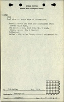
Gas explosions caused two deaths in 1928. Mine notes from 1908 indicate that the mine had some gas from the coal, but most originated in the roof. One large fault trended northeast-southwest, and many minor faults were present. The roof was considered bad, made up of 12 inches of limestone directly over the upper coal and over the lower coal, a lenticular black shale or a carbonaceous sandy shale with an overlying sandstone made up the roof. One of the source maps indicated rolls and faults in the south-central portion of the mine. The coal was “dirtier”, of lower quality, under areas where the sandstone was directly on top of the coal. Unconformities, rolls and faults were noted in the coal. The seam contained considerable tarry coal in thick and thin bands (generally thin), and characteristic partings of mother coal. The upper coal generally had very little pyrite, usually in the lower half of the bed and only occasionally in the top half. The pyrite was present as lenses 1 to 2 inches thick and 1 to 2 feet long. Calcite facings on the cleavage planes were very thin. The lower coal was called a “splint block coal” because of its tendency to fracture easily along the cleavage planes and come out in blocks. This lower coal was uniform quality from top to bottom.
Production
| Company
|
Mine Name
|
Date
|
Production (tons)
|
|
|
|
|
|
| Total Production: 2,157,928
|
Production Notes
Coal Report production (if available)Sources of Data
| Company
|
3-1922
|
1:1200
|
1:4025
|
Not final
|
| Company, 4103.C4 i5.1-4, sheet 1
|
4-1923
|
1:2400
|
1:2400
|
Not final
|
| Company, 4103.C4 i5.1-4, sheet 2
|
12-1923
|
1:2000
|
1:2000
|
Not final
|
| Company, IL_634
|
9-1907
|
1:1200
|
1:1200
|
Not final
|
Annotated Bibliography (Data source - brief description of information)
| Coal Reports - Production, ownership, years of operation, geologic problems.
|
| Directory of Illinois Coal Mines (Christian County) - Mine names, mine index, ownership, years of operation.
|
| Mine notes (Christian County) - Mine type, shaft location, seam, depth, thickness, geologic problems.
|
| Company map, state archive, il_632_03_geo.img - Shaft locations, mine outline, mining method.
|
| Company map, ISGS map library, 4103.C4 i5.1-4, sheet 1 - Mine outline (western portion).
|
| Company map, ISGS map library, 4103.C4 i5.1-4, sheet 2 - Mine outline (central portions, south and northwest).
|
| Company map, state archive, IL_634 - Mine outline (small projection in SE SW NW 2-T12N-R1E).
|
Mine Notes
Mine Images
Company: IL_634_01
Map Date: 9-1907
Coal Co.: Assumption Coal and Mining Company
Mine Name: Assumption Mine
Full Res Download
Company: il_632
Map Date: 3-1922
Coal Co.: Assumption Coal and Mining Company
Mine Name: Assumption
Full Res Download
Photographs