Mine Index Number: 0054
| Company Name:
|
Paradise Coal and Coke Company
|
| Mine Name:
|
Paradise Mine
|
| Start Date:
|
1904
|
End Date:
|
March 1927
|
| Type of Mine:
|
Underground
|
| Total acres shown:
|
997
|
| Acres after map date:
|
|
General Area of mining acres shown:
|
|
|
|
Shaft, Slope, Drift or Tipple Location(s)
| Type
|
County
|
Township-Range
|
Section
|
Part Section
|
| Main shaft
|
Perry
|
6S 1W
|
15
|
SE NW NE
|
| Air shaft
|
Perry
|
6S 1W
|
15
|
SE NE NE
|
Geology
| Herrin
|
371
|
8.0
|
12.0
|
9.0
|
RPP,HERA 1908 mine note states that all the pillars were drawn and the top coal was removed as areas were completed. The method may be HER in many areas of the mine.
|
Geological Problems Reported
Two faults were noted, one in the main west entry and one at the face. Both faults extended into the Davis Mine (mine index 3146). The faults emitted gas when first encountered, and moderate amounts of water. The cap rock was a limestone about 20 feet above the coal. Gray sandy shale was the immediate roof above the coal. It fell in slabby layers, sometimes as high as 20 feet. Rolls cut into the seam from the roof and floor. Top coal was left to support the roof, generally 26 to 30 inches. The blue band was in two layers. Other impurities included pyrite-bearing clay bands. These generally separated easily from the coal. The floor heaved badly.
Production
| Company
|
Mine Name
|
Date
|
Production (tons)
|
Production Notes
Coal Report production (if available)
Sources of Data
| Microfilm, document 352117
|
3-1927
|
1:2400
|
1:4138
|
Final
|
Annotated Bibliography (Data source - brief description of information)
| Coal Reports - Production, ownership, years of operation.
|
| Directory of Illinois Coal Mines (Perry County) - Mine names, mine index, ownership, years of operation.
|
| Mine notes (Perry County) - Mine type, shaft location, seam, depth, thickness, geologic problems.
|
| Microfilm map, document 352117, reel 03138, frames 115-118 - Shaft locations, mine outline, mining method.
|
| Microfilm map, document 352143, reel 03138, frames 160-163 - Identification of air shaft location.
|
Mine Notes
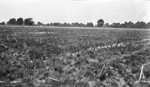
Mine Images
Photographs
Caption: North-West of shaft, 800 feet across by 3 feet deep with some water
Credit: Illinois State Geological Survey
Library No.: M-965

