Du Quoin Quadrangle
Mining in the Du Quoin Quadrangle
The earliest known mining took place northeast of Du Quoin in 1853. Cornelius & J. C. Storm opened a mine (mine index 3134) near the railroad tracks. More early mining occurred near the town now known as Sunfield. The town was platted in 1864, and named Diamond Town. The Black Diamond Coal Mining Company was organized in 1865, and presumably mining began shortly thereafter. The exact outline of this mine is not known, but has been inferred from the outline of Eaton Fuel Company’s Black Diamond Mine (mine index 178), which opened in 1903 and closed in 1941. Old Paradise Mine (mine index 3131) opened in 1867 near St. John, north of Du Quoin. According to an 1868 publication, mines near Du Quoin included the Du Quoin Central Mine, Du Quoin Mine, Mill Shaft, and Tijou Shaft (likely one of the Tishue mines included in mine index numbers 4394, 4397 and 4398).
The Herrin Coal was mined in the vicinity of Du Quoin, commonly having a thickness over 7 feet. The roof material was often problematical, with pods or lenses of white top that came down readily, associated with slips and rolls that further contributed to poor roof conditions. Energy Shale was also present in some areas, a gray sandy gray shale that is also known for providing a roof that falls readily. In most areas, a competent limestone was present above the shale, and in some cases, was the immediate roof over the coal. Pyrite was often present in bands, lenses and nodules, but most reported cases indicated the pyrite was easily removed, which was helpful to the coal quality in the time of hand loading. (Hand loading was prevalent before 1930, and common in some mines through the 1940s.)
Map and Directory PDF Download
Coal Mines In Illinois Du Quoin Quadrangle
Mines that Appear on the Du Quoin Quadrangle
Unlocated Mines
Perry County
Franklin County
Jefferson County
Pages in category "Du Quoin Quadrangle"
The following 69 pages are in this category, out of 69 total.
3
4
Media in category "Du Quoin Quadrangle"
The following 4 files are in this category, out of 4 total.
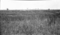 M-962 Sunfield mine Duquoin sag foreground and background high grass over pillar.jpg 4,376 × 2,586; 1.36 MB
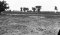
 M-965 Paradise Mine E of Duquoin NW of shaft 800ft across 3ft deep some wtr.jpg 4,344 × 2,539; 1.21 MB
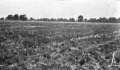
 M-967 Sunfield Mine typical Duquoin sag.jpg 4,355 × 2,541; 1.3 MB
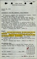 M4874 fieldnotes.pdf 752 × 1,197; 298 KB


