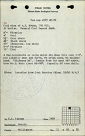
Mine Index Number: 0324
| Company Name:
|
Young Brothers
|
| Mine Name:
|
Young Mine
|
| Start Date:
|
1883
|
End Date:
|
1928
|
| Type of Mine:
|
Underground
|
| Total acres shown:
|
|
| Production Indicated Acres:
|
30
|
General Area of mining acres shown:
|
15
|
|
|
Shaft, Slope, Drift or Tipple Location(s)
| Type
|
County
|
Township-Range
|
Section
|
Part Section
|
| Main shaft
|
Williamson
|
9S 1E
|
11
|
NE NE NW
|
Geology
| Springfield
|
50
|
|
|
4.0-9.5
|
RP
|
Geological Problems Reported
Production
| Company
|
Mine Name
|
Date
|
Production (tons)
|
| Young Brothers
|
Young
|
1913-1928 Production not reported 1922 for mines producing less than 10,000 tons
|
50,325
|
|
|
|
|
|
|
|
| Total Production: 140,989
|
Production Notes
Coal Report production (if available)
Sources of Data
| ISGS map library, 4103.W52 i5.1-189
|
1934
|
1:63360
|
1:63360
|
Secondary source
|
Annotated Bibliography (Data source - brief description of information)
| Coal Reports - Production, ownership, years of operation, mining method, thickness, depth, mining method.
|
| Directory of Illinois Coal Mines (Williamson County) - Mine names, mine index, ownership, years of operation.
|
| Mine notes (Williamson County) - Mine type, shaft location, seam, depth, thickness.
|
| ISGS map library, 4103.W52 i5.1-189, work map for Federal Land Bank Report map - Shaft location, mine outline.
|
Mine Notes
Mine Images
 These files may not be true to scale and are not georgistered. These files may not be true to scale and are not georgistered.
|
Map Type:
|
|
| Map ID:
|
4103.w52 i5.1-189
|
| Company:
|
|
| Mine Name:
|
|
| Caption:
|
Work map for Federal Land Bank Report map
|
| Map Date:
|
8/11/34
|
| Map Status:
|
|
| Image Credit:
|
|
| Note:
|
|
| More Info:
|
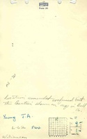
Willsn1.jpg
|
| Full Res Download:These files are true to scale and most are georegistered for gis software. These files may be a very large (>1GB) download!
|
https://wikiimage.isgs.illinois.edu/ilmines/williamson/willsn1.zip
|
Photographs