Mine Index Number: 0738
| Company Name:
|
United Electric Coal Company
|
| Mine Name:
|
United Electric No. 9 or Cuba Mine
|
| Start Date:
|
1923
|
End Date:
|
May 1971
|
| Type of Mine:
|
Surface
|
| Total acres shown:
|
7,225 In an outline that includes areas mined by Little Sister Mine (mine index 674), United Electric No. 9 Mine (mine index 738), and Triple S Mine (mine index 2148). Production indicates United Electric No. 9 Mine would have mined approximately 4,550 acres.
|
| Acres after map date:
|
|
General Area of mining acres shown:
|
|
|
|
Shaft, Slope, Drift or Tipple Location(s)
| Type
|
County
|
Township-Range
|
Section
|
Part Section
|
| Pit or tipple
|
Fulton
|
6N 3E
|
28
|
SW SW SW
|
Geology
| Springfield
|
47-73
|
|
|
4.75-5.6
|
Surface
|
Geological Problems Reported
Horsebacks were common and the clay-rich contents of the horseback-rich areas were separated from the loaded coal in the pit. Rolls were common, as were concretions in the roof material. The coal contained numerous shale partings, bone coal bands, and pyrite lenses, usually less than 1 inch thick.
Production
| Company
|
Mine Name
|
Date
|
Production (tons)
|
Production Notes
Coal Report production (if available)
Sources of Data
| Coal Section files, 1-29-9
|
12-31-1968
|
1:19200
|
1:19200
|
Not final
|
| USGS topographic map
|
1947, PR 1979
|
1:24000
|
1:24000
|
Secondary source
|
Annotated Bibliography (Data source - brief description of information)
| Coal Reports - Production, ownership, years of operation.
|
| Directory of Illinois Coal Mines (Fulton County) - Mine names, mine index, ownership, years of operation.
|
| Mine notes (Fulton County) - Mine type, mine location, seam, depth, thickness, geologic problems.
|
| Company map, Coal Section files, 1-29-9 - Mine outline, mining method.
|
| USGS 7.5-minute topographic map, Lewistown Quadrangle, 1947, photorevised 1979 - Mine outline.
|
Mine Notes
Mine Images
Photographs
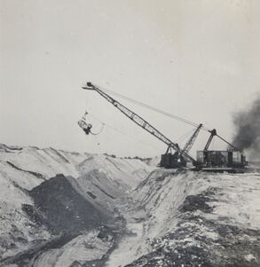
Caption: Surface mine pit, NE 30-T6N-R3E, dragline. Photographer G. Cady
Credit: Illinois State Geological Survey
Date: 6-25-1941
Library No.: 2316 (M-1513)
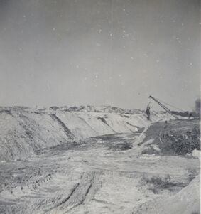
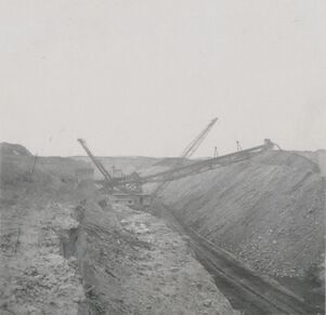
Caption: Surface mine, dragline in distance. Photographer: G. Cady
Credit: Illinois State Geological Survey
Date: 6-25-1941
Library No.: 2317 (M-1514)
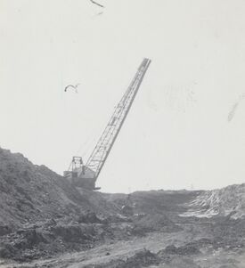
Caption: Surface mine, dragline. Photographer: G. Cady
Credit: Illinois State Geological Survey
Date: circa 1941
Library No.: 2462 (M-1659)
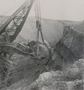
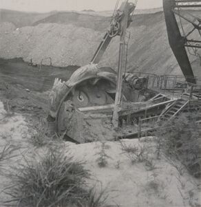
Caption: Excavating head of first Illinois bucketwheel excavator designed by Frank F. Kolbe of United Electric Coal Company. This was an economical method of moving a great volume of soil and shale and depositing it far enough away to prevent the spoil pile from sliding back into the pit. This wheel excavator could deposit to a spoil pile 400 ft away. Bucyrus built the upper portion onto a Marion dragline chassis. The machine weighed about 1,000 tons and had an output of 1,000 cubic yards of material per hour. This volume is about 5 times the rate of the Marion dragline model it replaced.
Credit: Illinois State Geological Survey
Date: 1949
Library No.: 2765 (M-1963)
Caption: Excavating head of bucketwheel excavator. Photographer: G. Cady
This is the first bucketwheel excavator, designed by Frank F. Kolbe of United Electric Coal Company. This was an economical method of moving a great volume of soil and shale and depositing it far enough away to prevent the spoil pile from sliding back into the pit. This wheel excavator could deposit to a spoil pile 400 ft away. Bucyrus built the upper portion onto a Marion dragline chassis. The machine weighed about 1,000 tons and had an output of 1,000 cubic yards of material per hour. This volume is about 5 times the rate of the Marion dragline model it replaced.
Credit: Illinois State Geological Survey
Date: 1949
Library No.: 2766 (M-1964)
Caption: Conveyor portion of bucketwheel excavator. Photographer: G. Cady
This is the first bucketwheel excavator in Illinois, designed by Frank F. Kolbe of United Electric Coal Company. This was an economical method of moving a great volume of soil and shale and depositing it far enough away to prevent the spoil pile from sliding back into the pit. This wheel excavator could deposit to a spoil pile 400 ft away. Bucyrus built the upper portion onto a Marion dragline chassis. The machine weighed about 1,000 tons and had an output of 1,000 cubic yards of material per hour. This volume is about 5 times the rate of the Marion dragline model it replaced.
Credit: Illinois State Geological Survey
Date: 1949
Library No.: 2767 (M-1965)

