Mine Index Number: 2099
| Company Name:
|
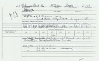
L. S. Robinson
|
| Mine Name:
|
Robinson Mine
|
| Start Date:
|
1940
|
End Date:
|
1944
|
| Type of Mine:
|
Underground
|
| Total acres shown:
|
None
|
| Production Indicated Acres:
|
3
|
General Area of mining acres shown:
|
|
|
|
Shaft, Slope, Drift or Tipple Location(s)
| Type
|
County
|
Township-Range
|
Section
|
Part Section
|
| Main shaft
|
Fulton
|
4N 2E
|
8
|
SW SW NW
|
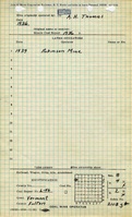
Geology
| Springfield
|
30-48
|
|
|
5.67-6.0
|
RP
|
Geological Problems Reported
Production
| Company
|
Mine Name
|
Date
|
Production (tons)
|
Production Notes
Coal Report production (if available)
Sources of Data
| ISGS field notes (Cady & Parks)
|
6-25-1941
|
1:62500
|
1:62500
|
Secondary source
|
Annotated Bibliography (Data source - brief description of information)
| Coal Reports - Production, ownership, years of operation.
|
| Directory of Illinois Coal Mines (Fulton County) - Mine names, mine index, ownership, years of operation.
|
| Mine notes (Fulton County) - Mine type, depth, thickness.
|
| Mine Inspector's reports, courtesy of Joe Pelc, IDNR - Mine type, seam, depth, thickness.
|
| ISGS field notes (Fulton County) - Mine location, depth.
|
Mine Notes
Mine Images
Photographs