Mine Index Number: 2594
| Company Name:
|
John Petrotte
|
| Mine Name:
|
Petrotte Mine
|
| Start Date:
|
1914
|
End Date:
|
1925
|
| Type of Mine:
|
Surface and Underground
|
| Total acres shown:
|
|
| Production Indicated Acres:
|
2
|
General Area of mining acres shown:
|
|
|
|
Shaft, Slope, Drift or Tipple Location(s)
| Type
|
County
|
Township-Range
|
Section
|
Part Section
|
| Pit
|
La Salle
|
31N 3E
|
22
|
NE SW SE
|
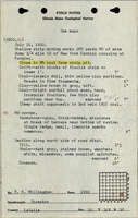
| DriftSurface mining took place the first two years (1914-1916), then, as depth increased, a drift entry was made off the highwall.
|
La Salle
|
31N 3E
|
22
|
NE SW SE
|
Geology
| Herrin
|
6-8
|
|
|
4.0-5.0
|
Surface and RP
|
Geological Problems Reported
Production
| Company
|
Mine Name
|
Date
|
Production (tons)
|
Production Notes
Coal Report production (if available)
Sources of Data
| Mine notes
|
Undated
|
1:62500
|
1:24000The mine location was plotted on a 1:24000 USGS topographic map from the mine location description and digitized.
|
Secondary source
|
Annotated Bibliography (Data source - brief description of information)
| Coal Reports - Production, ownership, years of operation, mine type, depth, thickness, mining method.
|
| Directory of Illinois Coal Mines (La Salle County) - Mine names, mine index, ownership, years of operation.
|
| Mine notes (La Salle County) - Mine location.
|
| ISGS field notes (La Salle County) - Drift location, depth (Spring Lake Coal).
|
Mine Notes
Mine Images
Photographs