Mine Index Number: 3309
| Company Name:
|
James Yates
|
| Mine Name:
|
Yates Mine
|
| Start Date:
|
1934
|
End Date:
|
1937
|
| Type of Mine:
|
Underground
|
| Total acres shown:
|
Production indicates less than 1 acre was mined.
|
| Acres after map date:
|
|
General Area of mining acres shown:
|
9
|
|
|
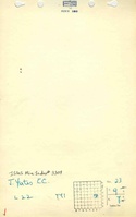
Shaft, Slope, Drift or Tipple Location(s)
| Type
|
County
|
Township-Range
|
Section
|
Part Section
|
| Main slope
|
Saline
|
9S 7E
|
23
|
SE NE SE
|
Geology
Geological Problems Reported
Production
| Company
|
Mine Name
|
Date
|
Production (tons)
|
Production Notes
Coal Report production (if available)
Sources of Data
| Federal Land Bank Report
|
1-12-1934
|
1:90514
|
1:90514
|
Secondary source
|
Annotated Bibliography (Data source - brief description of information)
| Coal Reports - Production, ownership, years of operation, mining method.
|
| Directory of Illinois Coal Mines (Saline County) - Mine names, mine index, ownership, years of operation.
|
| Mine notes (Saline County) - Mine type, slope location, seam, thickness.
|
| Federal Land Bank Report (Saline County) - Slope location, mine outline.
|
Mine Notes
Mine Images
Photographs