Mine Index Number: 3338
| Company Name:
|
Cosmo Coal Corporation
|
| Mine Name:
|
Cosmo Mine
|
| Start Date:
|
1923
|
End Date:
|
1941
|
| Type of Mine:
|
Underground
|
| Total acres shown:
|
23
|
| Acres after map date:
|
|
General Area of mining acres shown:
|
|
|
|
Shaft, Slope, Drift or Tipple Location(s)
| Type
|
County
|
Township-Range
|
Section
|
Part Section
|
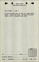
| Main shaft
|
Sangamon
|
14N 7W
|
18
|
SW SE NW
|
| Air shaft
|
Sangamon
|
14N 7W
|
18
|
NE SE NW
|
Geology
| Herrin
|
175
|
|
|
4.75
|
Underground
|
Geological Problems Reported
Production
| Company
|
Mine Name
|
Date
|
Production (tons)
|
Production Notes
Coal Report production (if available)
Sources of Data
| Microfilm, document 351251
|
6-12-1941
|
1:1200
|
1:2235
|
Final
|
| Microfilm, document 351215
|
8-27-1927
|
1:600
|
1:745
|
Not final
|
Annotated Bibliography (Data source - brief description of information)
| Coal Reports - Production, ownership, years of operation.
|
| Directory of Illinois Coal Mines (Sangamon County) - Mine names, mine index, ownership, years of operation.
|
| Mine notes (Sangamon County) - Mine type, shaft location, seam, depth, thickness.
|
| Microfilm map, document 351251, reel 03134, frame 504 - Shaft locations, mine outline (western), mining method.
|
| Microfilm map, document 351215, reel 03134, frame 407 - Shaft location (eastern), mine outline (eastern).
|
Mine Notes
Mine Images
Microfilm: 351251
Map Date: 6-12-1941
Coal Co.: Cosmo Coal Corp.
Mine Name: Cosmo Mine
Full Res Download
Microfilm: 351215
Map Date: 8-27-1927
Coal Co.: Cosmo Coal Corp.
Mine Name: Cosmo Mine
Full Res Download
Photographs
Additional Notes