Mine Index Number: 3350
| Company Name:
|
Panther Creek Mines, Inc.
|
| Mine Name:
|
Panther Creek No. 2 Mine
|
| Start Date:
|
1900
|
End Date:
|
1948
|
| Type of Mine:
|
Underground
|
| Total acres shown:
|
883
|
| Acres after map date:
|
|
General Area of mining acres shown:
|
|
|
|
Shaft, Slope, Drift or Tipple Location(s)
| Type
|
County
|
Township-Range
|
Section
|
Part Section
|
| Shaft
|
Sangamon
|
16N 5W
|
21
|
NE SE SW
|
| Air shaft
|
Sangamon
|
16N 5W
|
21
|
NE NE NW
|
| Air / escape shaft
|
Sangamon
|
16N 5W
|
21
|
NE SE SW
|
Geology
| Springfield
|
200
|
|
5.8
|
5.6
|
RPP
|
Geological Problems Reported
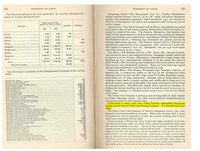
Production
| Company
|
Mine Name
|
Date
|
Production (tons)
|
|
|
|
|
|
| Total Production: 3,216,826
|
Production Notes
Coal Report production (if available)
Sources of Data
| Microfilm, document 351208 Map of Panther Creek No. 5 (mine index 3351), used for location of air shaft in north half of section 21.
|
4-15-1952
|
1:2400
|
1:5297
|
Final
|
| Microfilm, document 351203
|
4-1948
|
1:2400
|
1:3972
|
Final
|
Annotated Bibliography (Data source - brief description of information)
| Coal Reports - Production, ownership, years of operation.
|
| Directory of Illinois Coal Mines (Sangamon County) - Mine names, mine index, ownership, years of operation.
|
| ENR Document 85/01 - Mining method.
|
| Mine notes (Sangamon County) - Depth, thickness.
|
| Microfilm map, document 351203, reel 03134, frames 370-372 - Shaft locations, mine outline.
|
| Microfilm map, document 351208, reel 03134, frame 393 - Shaft location.
|
Mine Notes
Mine Images
Microfilm: 351208
Map Date: 4-15-1952
Coal Co.: Panther Creek Mines, Inc.
Mine Name: Panther Creek No. 5 Mine
Photographs
Caption: Houses in northwest Springfield for which claims were paid by a mining company for damages caused by mining coal 5 feet 9 inches thick at a depth of about 200 feet.
Credit: Illinois State Geological Survey
Date: Pre-1914
Publication: Fig. 44 Cooperative Bulletin 17 – Subsidence in Illinois
Library No.: M-1003
Caption: Houses in northwest Springfield for which claims were paid by a mining company for damages caused by mining coal 5 feet 9 inches thick at a depth of about 200 feet. See M-1003 and M-1006
Credit: Illinois State Geological Survey
Date: Pre-1914
Library No.: M-1004
Caption: Houses in northwest Springfield for which claims were paid by a mining company for damages caused by mining coal 5 feet 9 inches thick at a depth of about 200 feet.
Credit: Illinois State Geological Survey
Date: Pre-1914
Library No.: M-1005
Caption: Houses in northwest Springfield for which claims were paid by a mining company for damages caused by mining coal 5 feet 9 inches thick at a depth of about 200 feet. See M-1004
Credit: Illinois State Geological Survey
Library No.: M-1006