Mine Index Number: 3367
| Company Name:
|
Happy Hollow Coal Company
|
| Mine Name:
|
Happy Hollow Mine
|
| Start Date:
|
1909
|
End Date:
|
1949
|
| Type of Mine:
|
Underground
|
| Total acres shown:
|
77 Production indicates 44 acres were mined. The northern portion of the mine was designated “worked out” on the source map, and there were most likely large pillars and unmined areas within the outline.
|
| Acres after map date:
|
2
|
General Area of mining acres shown:
|
|
|
|
Shaft, Slope, Drift or Tipple Location(s)
| Type
|
County
|
Township-Range
|
Section
|
Part Section
|
| Main shaft
|
Sangamon
|
17N 7W
|
35
|
SW SW NW
|
| Air / escape shaft
|
Sangamon
|
17N 7W
|
35
|
SW SW NW
|
Geology
| Springfield
|
108
|
3.5
|
|
5.0
|
MRP
|
Geological Problems Reported
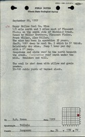
The immediate roof was 18 inches to 4 feet of shaley clod, which generally came down and was gobbed. Very few concretions were seen in the northern portion of the mine, with a higher density in the central and southern portion under the hill. Many horsebacks and clay veins were noted in the seam. Some rolls were noted. The underclay was fairly soft and squeezes were a problem.
Production
| Company
|
Mine Name
|
Date
|
Production (tons)
|
|
|
|
|
|
| Total Production: 202,112
|
Production Notes
Coal Report production (if available)
Sources of Data
| Microfilm, document 351191
|
6-18-1948
|
1:2400
|
1:5131
|
Not final
|
Annotated Bibliography (Data source - brief description of information)
| Coal Reports - Production, ownership, years of operation.
|
| Directory of Illinois Coal Mines (Sangamon County) - Mine names, mine index, ownership, years of operation.
|
| Mine notes (Sangamon County) - Mine type, shaft location, seam, depth, thickness, geologic problems.
|
| ISGS field notes (R. W. Brown, 9-20-1929) - Depth, geologic problems.
|
| Microfilm map, document 351191, reel 03134, frame 350 - Shaft locations, mine outline, mining method.
|
Mine Notes
Mine Images
Microfilm: 351191
Map Date: 6-18-1948
Coal Co.: Happy Hollow Coal Co.
Mine Name: Happy Hollow Mine
Full Res Download
Photographs
Additional Notes