Mine Index Number: 3503
| Company Name:
|
Consolidated Coal Company of St. Louis
|
| Mine Name:
|
Dutch Hollow Mine
|
| Start Date:
|
1874
|
End Date:
|
1895
|
| Type of Mine:
|
Underground
|
| Total acres shown:
|
66
|
| Acres after map date:
|
24
|
General Area of mining acres shown:
|
|
|
Connected underground to Knecht Mine (mine index 3502) and Oakland Mine (mine index 3500).
|
Shaft, Slope, Drift or Tipple Location(s)
| Type
|
County
|
Township-Range
|
Section
|
Part Section
|
| Main shaft
|
St. Clair
|
1N 8W
|
7
|
NW NW NE
|
| Air shaft
|
St. Clair
|
1N 8W
|
7
|
NW NW NE
|
Geology
| Herrin
|
120-142
|
|
|
5.5-7.0
|
RPB
|
Geological Problems Reported
Production
| Company
|
Mine Name
|
Date
|
Production (tons)
|
|
|
|
|
|
| Total Production: 192,816
|
Production Notes
Coal Report production (if available)
Sources of Data
| Microfilm, document 350977
|
5-30-1885
|
1:960
|
1:1721
|
Not final
|
| ISGS map library, 4103.S31 i5.1-49
|
3-21-1903
|
1:2400
|
1:4966
|
Secondary source
|
Annotated Bibliography (Data source - brief description of information)
| Coal Reports - Production, ownership, years of operation.
|
| Directory of Illinois Coal Mines (St. Clair County) - Mine names, mine index, ownership, years of operation.
|
| Microfilm map, document 350977, reel 03134, frame 40 - Shaft locations, mine outline, mining method.
|
| ISGS map library, 4103.S31 i5.1-49, map of Knecht Mine (mine index 3502) - Mine outline (western).
|
| Mine notes (St. Clair County) - Thickness, depth, seam, mine type, shaft location.
|
| Atlas of St. Clair County, Illinois, 1874, Warner and Beers, Chicago, Illinois - Years of operation.
|
Mine Notes
Mine Images
Atlas:
Map Date: 1874
Coal Co.: Daniel Knecht
Mine Name: Knecht Mine
Company: 4103.S31 i5.1-49
Map Date: 3-21-1903
Coal Co.: Consolidated Coal Company of St. Louis
Mine Name: Knecht Mine
Full Res Download
Microfilm: 350977
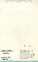
Map Date: 5-30-1885
Coal Co.: Dutch Hollow Coal Company
Mine Name: Dutch Hollow Mine
Full Res Download
Photographs