Mine Index Number: 3640
| Company Name:
|
Pekin Coal Mining Company
|
| Mine Name:
|
Pekin Mine
|
| Start Date:
|
1913
|
End Date:
|
1953
|
| Type of Mine:
|
Underground
|
| Total acres shown:
|
380
|
| Acres after map date:
|
|
General Area of mining acres shown:
|
|
|
|
Shaft, Slope, Drift or Tipple Location(s)
| Type
|
County
|
Township-Range
|
Section
|
Part Section
|
| Main shaft
|
Tazewell
|
25N 5W
|
36
|
NE SE SW
|
| Air shaft
|
Tazewell
|
25N 5W
|
36
|
SE SE SW
|
Geology
| Springfield
|
100
|
|
|
4.5-4.83
|
RPP
|
Geological Problems Reported
Concretions were abundant in the black shale above the coal.
Production
| Company
|
Mine Name
|
Date
|
Production (tons)
|
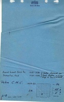
| David Grant
|
Grant
|
1914-1925
|
94,753Production not reported in 1922 for mines producing less than 10,000 tons
|
|
|
|
|
|
|
|
| Total Production: 1,373,817
|
Production Notes
Coal Report production (if available)
Sources of Data
| Microfilm, document 352861
|
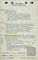
3-17-1953
|
1:2400
|
1:4800
|
Final
|
Annotated Bibliography (Data source - brief description of information)
| Coal Reports - Production, ownership, years of operation, thickness.
|
| Directory of Illinois Coal Mines (Tazewell County) - Mine names, mine index, ownership, years of operation.
|
| Mine notes (Tazewell County) - Mine type, shaft location, seam.
|
| ISGS field notes (Tazewell County) - Depth, geologic problems.
|
| Microfilm map, document 352861, reel 03140, frame 488 - Shaft locations, mine outline, mining method.
|
Mine Notes
Mine Images
![[[:Pekin|Pekin]]](https://wikiimage.isgs.illinois.edu/ilmines/tazewell/thumbnails/m3640_th.jpg) These files may not be true to scale and are not georgistered. These files may not be true to scale and are not georgistered.
|
Map Type:
|
Microfilm
|
| Map ID:
|
352861 03140, 488, 29x
|
| Company:
|
Pekin Coal Mining Company
|
| Mine Name:
|
Pekin
|
| Caption:
|
|
| Map Date:
|
3-17-1953
|
| Map Status:
|
Final
|
| Image Credit:
|
|
| Note:
|
|
| More Info:
|
M3640
|
| Full Res Download:These files are true to scale and most are georegistered for gis software. These files may be a very large (>1GB) download!
|
https://wikiimage.isgs.illinois.edu/ilmines/tazewell/m3640.zip
|
Photographs