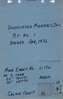
Mine Index Number: 4184
| Company Name:
|
Diversified Minerals
|
| Mine Name:
|
Diversified Mine
|
| Start Date:
|
1972
|
End Date:
|
1972
|
| Type of Mine:
|
Surface
|
| Total acres shown:
|
None
|
| Acres after map date:
|
approximately 3
|
General Area of mining acres shown:
|
|
|
|
Shaft, Slope, Drift or Tipple Location(s)
| Type
|
County
|
Township-Range
|
Section
|
Part Section
|
| Pit # 1 (January 1972)
|
Saline
|
10S 7E
|
13
|
SE SW
|
| Pit # 2 (July 1972)
|
Saline
|
10S 7E
|
14
|
SW
|
Geology
| Springfield (Pit #1)
|
45
|
|
|
5.0
|
Auger
|
| Davis (Pit #2)
|
180
|
|
|
3.0-4.0
|
Auger
|
Geological Problems Reported
Production
| Company
|
Mine Name
|
Date
|
Production (tons)
|
Production Notes
Coal Report production (if available)
Sources of Data
| Mine notes
|
Undated
|
(text only)
|
1:24000The mine location was plotted on a 1:24000 USGS topographic map from the mine location description and digitized.
|
Secondary source
|
Annotated Bibliography (Data source - brief description of information)
| Coal Reports - Production, ownership, years of operation.
|
| Directory of Illinois Coal Mines (Saline County) - Mine names, mine index, ownership, years of operation.
|
| Mine notes (Saline County) - Mine type, pit locations, seam, depth, thickness, mining method.
|
Mine Notes
Mine Images
Photographs