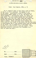
Mine Index Number: 6808
| Company Name:
|
Hawley Coal Company
|
| Mine Name:
|
Hawley Mine
|
| Start Date:
|
Pre 1873
|
End Date:
|
1896
|
| Type of Mine:
|
Underground
|
| Total acres shown:
|
6
|
| Acres after map date:
|
42
|
General Area of mining acres shown:
|
|
|
|
Shaft, Slope, Drift or Tipple Location(s)
| Type
|
County
|
Township-Range
|
Section
|
Part Section
|
| Main shaft
|
Tazewell
|
24N 5W
|
23
|
NE SE
|
Geology
| Springfield
|
75-85
|
|
|
4.0-4.5
|
RP
|
Geological Problems Reported
Production
| Company
|
Mine Name
|
Date
|
Production (tons)
|
| Norman C. Hawley
|
Hawley
|
pre-1873-1887
|
70,780Production and years of operation prior to July 1878 and July 1879 to June 1881 are unknown. The 1873 plat and atlas of Tazewell County showed Hawley’s mine, indicating that it was a substantial operation by 1873.
|
|
|
|
|
|
|
|
| Total Production: 163,789
|
Production Notes
Coal Report production (if available)
Sources of Data
| Atlas Map of Tazewell County
|
1873
|
1:42240
|
1:42240
|
Secondary source
|
Annotated Bibliography (Data source - brief description of information)
| Coal Reports - Production, ownership, years of operation, mine type, seam, depth, thickness, mining method.
|
| Directory of Illinois Coal Mines (Tazewell County) - Mine names, mine index, ownership, years of operation.
|
| Andreas, A. T., 1873, Atlas Map of Tazewell County, Illinois: Davenport, Iowa, Andreas, Lyter & Co., 165p. - Mine location.
|
Mine Notes
Mine Images
 These files may not be true to scale and are not georgistered. These files may not be true to scale and are not georgistered.
|
Map Type:
|
|
| Map ID:
|
Atlas Map of Tazewell County
|
| Company:
|
|
| Mine Name:
|
|
| Caption:
|
|
| Map Date:
|
1873
|
| Map Status:
|
|
| Image Credit:
|
|
| Note:
|
|
| More Info:
|
Tazewell 1873
|
| Full Res Download:These files are true to scale and most are georegistered for gis software. These files may be a very large (>1GB) download!
|
https://wikiimage.isgs.illinois.edu/ilmines/tazewell/tazewell 1873.zip
|
Photographs