Perry
Alan.Myers (talk | contribs) (Created page with "__NOTOC__{{#css:#ca-key1 { display:none!important; } }} ==Coal Mines== This county map displays coal mines and/or underground industrial mineral mines. If coal mining has occ...") |
Alan.Myers (talk | contribs) |
||
| Line 15: | Line 15: | ||
===Quadrangle Coal Mine Maps and Directories located in {{SUBPAGENAME}} County=== | ===Quadrangle Coal Mine Maps and Directories located in {{SUBPAGENAME}} County=== | ||
These selected 7.5-minute quadrangle maps are available online as PDF versions and show active and abandoned mines and their known extent on a topographic map base which includes township, range, and section lines and surface features such as roads, towns, lakes, and rivers. The mines are color-coded by mining method and the relative precision and completeness of the source map used for the mine boundary are indicated. Scale 1:24,000. Accompanying each map is a directory that gives a brief history of mining on the quadrangle and lists for each mine the location of mine opening and tipples; the name, thickness, and depth of seams mined; production history; geologic problems reported; company names; mine names and numbers; type of mine; years operated; coal seam mined; and mine location. | These selected 7.5-minute quadrangle maps are available online as PDF versions and show active and abandoned mines and their known extent on a topographic map base which includes township, range, and section lines and surface features such as roads, towns, lakes, and rivers. The mines are color-coded by mining method and the relative precision and completeness of the source map used for the mine boundary are indicated. Scale 1:24,000. Accompanying each map is a directory that gives a brief history of mining on the quadrangle and lists for each mine the location of mine opening and tipples; the name, thickness, and depth of seams mined; production history; geologic problems reported; company names; mine names and numbers; type of mine; years operated; coal seam mined; and mine location.<br> | ||
[https://wikiimage.isgs.illinois.edu/ilmines/webfiles/topo-mines/ava.pdf Ava Quadrangle Map and Directory]<br> | |||
[https://wikiimage.isgs.illinois.edu/ilmines/webfiles/topo-mines/coulterville.pdf Coulterville Quadrangle Map and Directory]<br> | |||
[https://wikiimage.isgs.illinois.edu/ilmines/webfiles/topo-mines/du-quoin.pdf Du Quoin Quadrangle Map and Directory]<br> | |||
[https://wikiimage.isgs.illinois.edu/ilmines/webfiles/topo-mines/elkville.pdf Elkville Quadrangle Map and Directory]<br> | |||
[https://wikiimage.isgs.illinois.edu/ilmines/webfiles/topo-mines/percy.pdf Percy Quadrangle Map and Directory]<br> | |||
[https://wikiimage.isgs.illinois.edu/ilmines/webfiles/topo-mines/pinckneyville.pdf Pinckneyville Quadrangle Map and Directory]<br> | |||
[https://wikiimage.isgs.illinois.edu/ilmines/webfiles/topo-mines/pyatts.pdf Pyatts Quadrangle Map and Directory]<br> | |||
[https://wikiimage.isgs.illinois.edu/ilmines/webfiles/topo-mines/sesser.pdf Sesser Quadrangle Map and Directory]<br> | |||
[https://wikiimage.isgs.illinois.edu/ilmines/webfiles/topo-mines/tamaroa.pdf Tamaroa Quadrangle Map and Directory]<br> | |||
[https://wikiimage.isgs.illinois.edu/ilmines/webfiles/topo-mines/todds-mill.pdf Todds Mill Quadrangle Map and Directory]<br> | |||
[https://wikiimage.isgs.illinois.edu/ilmines/webfiles/topo-mines/vergennes.pdf Vergennes Quadrangle Map and Directory]<br> | |||
[https://wikiimage.isgs.illinois.edu/ilmines/webfiles/topo-mines/willisville.pdf Willisville Quadrangle Map and Directory]<br> | |||
[https://wikiimage.isgs.illinois.edu/ilmines/webfiles/topo-mines/winkle.pdf Winkle Quadrangle Map and Directory] | |||
===ILMINES WIKI=== | ===ILMINES WIKI=== | ||
The links below contain much of the same information as the downloadable directories above. But has links to additional information such as mine map downloads, additional Mine Notes downloads, and other data.<br> | The links below contain much of the same information as the downloadable directories above. But has links to additional information such as mine map downloads, additional Mine Notes downloads, and other data.<br> | ||
[[:Category:Perry-County|Perry County]]<br> | |||
[[:Category:Ava-Quadrangle|Ava Quadrangle]]<br> | |||
[[:Category:Coulterville-Quadrangle|Coulterville Quadrangle]]<br> | |||
[[:Category:Du Quoin-Quadrangle|Du Quoin Quadrangle]]<br> | |||
[[:Category:Elkville-Quadrangle|Elkville Quadrangle]]<br> | |||
[[:Category:Percy-Quadrangle|Percy Quadrangle]]<br> | |||
[[:Category:Pinckneyville-Quadrangle|Pinckneyville Quadrangle]]<br> | |||
[[:Category:Pyatts-Quadrangle|Pyatts Quadrangle]]<br> | |||
[[:Category:Sesser-Quadrangle|Sesser Quadrangle]]<br> | |||
[[:Category:Tamaroa-Quadrangle|Tamaroa Quadrangle]]<br> | |||
[[:Category:Todds Mill-Quadrangle|Todds Mill Quadrangle]]<br> | |||
[[:Category:Vergennes-Quadrangle|Vergennes Quadrangle]]<br> | |||
[[:Category:Willisville-Quadrangle|Willisville Quadrangle]]<br> | |||
[[:Category:Winkle-Quadrangle|Winkle Quadrangle]] | |||
==Coal Resources== | ==Coal Resources== | ||
Revision as of 10:08, March 2, 2022
Coal Mines
This county map displays coal mines and/or underground industrial mineral mines. If coal mining has occurred in this county, a directory of additional information about these coal mines is included with the map. Buffer regions for industrial mineral mines were incorporated into this map due to limited information regarding these mines. The size of the buffer region is dependent on the uncertainty or inaccuracy of the mine location. For more information regarding industrial mineral mines please contact the ISGS Industrial Minerals Section. The county maps also display quadrangle boundaries for which the ISGS has completed studies. Scale 1:100,000. PDF file.
The accompanying coal mine directory provides basic information about the coal mines. PDF file.

|

|
| perry County Mine Map | perry County Mine Directory |
|---|
Quadrangle Coal Mine Maps and Directories located in Perry County
These selected 7.5-minute quadrangle maps are available online as PDF versions and show active and abandoned mines and their known extent on a topographic map base which includes township, range, and section lines and surface features such as roads, towns, lakes, and rivers. The mines are color-coded by mining method and the relative precision and completeness of the source map used for the mine boundary are indicated. Scale 1:24,000. Accompanying each map is a directory that gives a brief history of mining on the quadrangle and lists for each mine the location of mine opening and tipples; the name, thickness, and depth of seams mined; production history; geologic problems reported; company names; mine names and numbers; type of mine; years operated; coal seam mined; and mine location.
Ava Quadrangle Map and Directory
Coulterville Quadrangle Map and Directory
Du Quoin Quadrangle Map and Directory
Elkville Quadrangle Map and Directory
Percy Quadrangle Map and Directory
Pinckneyville Quadrangle Map and Directory
Pyatts Quadrangle Map and Directory
Sesser Quadrangle Map and Directory
Tamaroa Quadrangle Map and Directory
Todds Mill Quadrangle Map and Directory
Vergennes Quadrangle Map and Directory
Willisville Quadrangle Map and Directory
Winkle Quadrangle Map and Directory
ILMINES WIKI
The links below contain much of the same information as the downloadable directories above. But has links to additional information such as mine map downloads, additional Mine Notes downloads, and other data.
Perry County
Ava Quadrangle
Coulterville Quadrangle
Du Quoin Quadrangle
Elkville Quadrangle
Percy Quadrangle
Pinckneyville Quadrangle
Pyatts Quadrangle
Sesser Quadrangle
Tamaroa Quadrangle
Todds Mill Quadrangle
Vergennes Quadrangle
Willisville Quadrangle
Winkle Quadrangle
Coal Resources
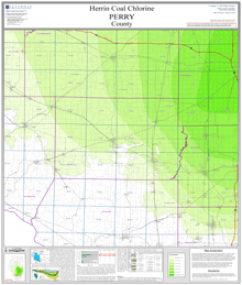
County structural elevation, depth, and thickness maps. Scale 1:100,000. PDF files.
Elevation
Depth
Thickness
Sulfur
Chlorine
|
| Herrin Coal Map |
|---|
On demand plots available for these maps! If you are unable to make your own large size plots from these PDF's we also offer an on demand plot for individual maps from our publication and sales office—for cost of the plot and handling. Please contact the ISGS at (217) 244-2414, or email at sales@prairie.illinois.edu(link sends e-mail) for more information on purchasing plots and other details.
Coal Logs
The PDF file contains non-confidential coal log descriptions from the Coal Section's stratigraphic database in the county listed. Coal logs are sorted by township/range and section.
You can download the raw .dbf files from which the stratigraphic database is derived (if such files are what you require; most users will only want the PDF files).
Each PDF file has a summary sheet that contains an overview of data and geology for the county. Each coal log has a "header" element that contains location information, log type, log source and other information. For each log, North American Datum 1983 (NAD83) Longitude/Latitude coordinates in decimal degrees are provided as well as a legal description which uses the Public Land Survey System (PLSS).
Beneath the header is geology information for that data point. The Coal Section stratigraphic database from which this .PDF file is derived is a multi-project database which contains drill hole and outcrop descriptions of Pennsylvanian stratigraphy in Illinois. Consequently, the level of detail and accuracy in the data and their interpretation vary (sometimes widely) with the geologist, project type, or original data source. Multiple descriptions of a particular location may be present. Note that both the coal stratigraphic database and this .PDF listing are only a subset of the total amount of data available from the ISGS Geologic Records Library archives, and reflect only coal-specific data and interpretations of past and present Coal Section geologists. They are not a comprehensive listing of all data that may be available from the ISGS.