Mine Index Number: 0124
| Company Name:
|
Peabody Coal Company
|
| Mine Name:
|
Peabody No. 47 Mine
|
| Start Date:
|
1916
|
End Date:
|
April 1951
|
| Type of Mine:
|
Underground
|
| Total acres shown:
|
4,595
|
| Acres after map date:
|
|
General Area of mining acres shown:
|
|
|
|
Shaft, Slope, Drift or Tipple Location(s)
| Type
|
County
|
Township-Range
|
Section
|
Part Section
|
| Main shaft
|
Saline
|
8S 5E
|
27
|
SE SE SW
|
| Air shaft
|
Saline
|
8S 5E
|
27
|
NE SE SW
|
Geology
| Springfield
|
416-420
|
4.5
|
8.0
|
4.67-6.0
|
RPP
|
Geological Problems Reported
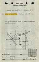
A 1921 gas explosion killed 12 miners, and a 1920 gas explosion killed 1 man. Faults were present throughout the mine, most trending northwest-southeast. Some halted mine expansion. Others were mined through, but the amounts of displacement were not noted on the source map. Above the coal was a shale that made a competent roof, except during humid summer when the shale “sweated” and slabbed off, producing many falls. The northernmost part of the mine had several areas identified as bad top. This same area was also shown on the source map to have a two-foot split of rock in the middle of the coal. In the southern part of the mine, an area was labeled ‘squeeze’. Some pyrite concretions and lenses were found in the coal. The floor, which was 2 to 3 feet of shale, heaved some, but was underlain by hard limestone.
Production
| Company
|
Mine Name
|
Date
|
Production (tons)
|
|
|
|
|
|
| Total Production: 21,011,617
|
Production Notes
Coal Report production (if available)
Sources of Data
| State archive, IL_2590
|
4-27-1951
|
1:12000
|
1:12000
|
Final
|
Annotated Bibliography (Data source - brief description of information)
| Coal Reports - Production, ownership, years of operation, geologic problems.
|
| Directory of Illinois Coal Mines (Saline County) - Mine names, mine index, ownership, years of operation.
|
| Mine notes (Saline County) - Mine type, shaft location, seam, thickness, geologic problems.
|
| State archive, IL_2590 - Shaft locations, mine outline, mining method, depth, geologic problems.
|
Mine Notes
Mine Images
![[[:Peabody No. 47|Peabody No. 47]]](https://wikiimage.isgs.illinois.edu/ilmines/saline/thumbnails/m0124_IL_2590_03_th.jpg) These files may not be true to scale and are not georgistered. These files may not be true to scale and are not georgistered.
|
Map Type:
|
State Archive
|
| Map ID:
|
IL_2590
|
| Company:
|
Peabody Coal Company
|
| Mine Name:
|
Peabody No. 47
|
| Caption:
|
|
| Map Date:
|
04-27-1951
|
| Map Status:
|
Final
|
| Image Credit:
|
|
| Note:
|
|
| More Info:
|
M0124 IL 2590 03
|
| Full Res Download:These files are true to scale and most are georegistered for gis software. These files may be a very large (>1GB) download!
|
https://go.illinois.edu/ILMImages/saline/m0124 IL 2590 03.zip
|
Photographs