Mine Index Number: 0219
| Company Name:
|
Peabody Coal Company
|
| Mine Name:
|
Peabody No. 9 Mine
|
| Start Date:
|
1918
|
End Date:
|
1951
|
| Type of Mine:
|
Underground
|
| Total acres shown:
|
5,769
|
| Acres after map date:
|
|
General Area of mining acres shown:
|
|
|
|
Shaft, Slope, Drift or Tipple Location(s)
| Type
|
County
|
Township-Range
|
Section
|
Part Section
|
| Main shaft
|
Christian
|
13N 2W
|
19
|
NE SE NW
|
| Air shaft
|
Christian
|
13N 2W
|
19
|
SW SW NE
|
Geology
| Herrin
|
407-417
|
4.0
|
9.0
|
7.5
|
RPP
|
Geological Problems Reported
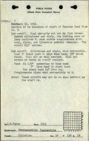
The source map shows problem areas designated along the southwestern edge and all along the north and northwestern side of the mine. The symbol is thought to denote sandstone channels. Channels or associated wet areas (from the water seeping from the sandstone) may have also caused some of the problems that resulted in the larger interior un-mined areas. The roof in the eastern and western parts of the mine was black shale, while gray shale predominated in the southeastern part of the mine. The sandy shale in the northeastern part was very dangerous and gave much trouble, because micaceous layers separating the bedding planes parted readily and allowed large parts of the roof to come down. This sandy shale was either directly on the coal or separated from it by 4 to 36 inches of black shale. A persistent pyrite layer in the coal ranged up to 1.5 inches thick. Pyrite lenses up to 1 inch thick were common. The source map shows faulty areas along the northern and southern borders of the mine.
Production
| Company
|
Mine Name
|
Date
|
Production (tons)
|
Production Notes
Coal Report production (if available)
Sources of Data
| Company
|
5-29-1952
|
1:4800
|
1:4800
|
Final
|
| Microfilm, document 351393
|
5-29-1952
|
1:4800
|
1:9600
|
Final
|
Annotated Bibliography (Data source - brief description of information)
| Coal Reports - Production, ownership, years of operation.
|
| Directory of Illinois Coal Mines (Christian County) - Mine names, mine index, ownership, years of operation.
|
| ENR Document 85/01 - Mining method.
|
| Mine notes (Christian County) - Mine type, shaft location, seam, depth, thickness, geologic problems.
|
| Company map, ISGS map library, 4103.C4 i5.1-6, copy 1 - Shaft locations, mine outline, mining method, geologic problems.
|
| Microfilm map, document 351393, reel 03135, frames 470-475, map of Peabody #7 (mine index 2040) - Mine outline (far NW part of mine).
|
Mine Notes
Mine Images
Company: 4103.C4 i5.1-6
Map Date: 5-29-1952
Coal Co.: Peabody Coal Company
Mine Name: Peabody No. 9
Image Credit: Illinois State Geological Survey
Full Res Download
Microfilm: 351393
Map Date: 5-29-1952
Coal Co.: Peabody Coal Company
Mine Name: Peabody No. 7 Mine
Image Credit: Illinois State Geological Survey
Full Res Download
Photographs