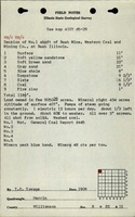
Mine Index Number: 0435
| Company Name:
|
Western Coal and Mining Company
|
| Mine Name:
|
Western No. 1 or Bush Mine
|
| Start Date:
|
1903
|
End Date:
|
June 1917
|
| Type of Mine:
|
Underground
|
| Total acres shown:
|
588
|
| Acres after map date:
|
|
General Area of mining acres shown:
|
|
|
|
Shaft, Slope, Drift or Tipple Location(s)
| Type
|
County
|
Township-Range
|
Section
|
Part Section
|
| Main shaft (9.5 x 19.5 ft)
|
Williamson
|
8S 1E
|
8
|
NW NW NW
|
| Air shaft
|
Williamson
|
8S 1E
|
8
|
SW NW NW
|
Geology
| Herrin
|
118-185
|
|
|
6.5-9.0
|
RPP
|
Geological Problems Reported
The roof was poor, a shale that slaked off after exposure. Bad top and water were noted on the source map in 8-T8S-R1E. Generally, 1.5 to 2 feet of top coal was left to support the roof.
Production
| Company
|
Mine Name
|
Date
|
Production (tons)
|
|
|
|
|
|
| Total Production: 3,389,204
|
Production Notes
Coal Report production (if available)
Sources of Data
| Microfilm, document 353303
|
9-10-1917
|
1:2400
|
1:4634
|
Final
|
Annotated Bibliography (Data source - brief description of information)
| Coal Reports - Production, ownership, years of operation, mining method, depth, thickness.
|
| Directory of Illinois Coal Mines (Williamson County) - Mine names, mine index, ownership, years of operation.
|
| Mine notes (Williamson County) - Mine type, shaft location, seam, geologic problems.
|
| Microfilm map, document 353303, reel 03142, frames 266 and 267 - Shaft locations, mine outline, mining method, geologic problems.
|
Mine Notes
Mine Images
![[[:Western No. 1|Western No. 1]]](https://wikiimage.isgs.illinois.edu/ilmines/williamson/thumbnails/m0435_th.jpg) These files may not be true to scale and are not georgistered. These files may not be true to scale and are not georgistered.
|
Map Type:
|
Microfilm
|
| Map ID:
|
353303 3142 266-267, 28x
|
| Company:
|
Western Coal and Mining Company
|
| Mine Name:
|
Western No. 1
|
| Caption:
|
|
| Map Date:
|
09/10/1917
|
| Map Status:
|
Final
|
| Image Credit:
|
|
| Note:
|
|
| More Info:
|
M0435.jpg
|
| Full Res Download:These files are true to scale and most are georegistered for gis software. These files may be a very large (>1GB) download!
|
https://wikiimage.isgs.illinois.edu/ilmines/williamson/m0435.zip
|
Photographs