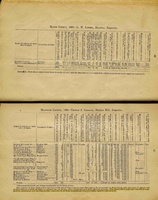
Mine Index Number: 2911
| Company Name:
|
Bremen Coal Company
|
| Mine Name:
|
Bremen Mine
|
| Start Date:
|
1882
|
End Date:
|
1894
|
| Type of Mine:
|
Underground
|
| Total acres shown:
|
|
| Acres after map date:
|
|
General Area of mining acres shown:
|
33
|
|
|
Shaft, Slope, Drift or Tipple Location(s)
| Type
|
County
|
Township-Range
|
Section
|
Part Section
|
| Main shaft This mine also had an escapement shaft, but no source for escapement shaft has been found.
|
Macoupin
|
9N 9W
|
2
|
NW NW SW
|
Geology
| Colchester
|
240
|
|
|
2.83-3.67
|
LW (old longwall)
|
Geological Problems Reported
Production
| Company
|
Mine Name
|
Date
|
Production (tons)
|
Production Notes
Coal Report production (if available)
Sources of Data
| Federal Land Bank Report
|
4-1934
|
1:126720
|
1:126720
|
Secondary source
|
Annotated Bibliography (Data source - brief description of information)
| Coal Reports - Production, ownership, years of operation, depth, thickness, mining method.
|
| Directory of Illinois Coal Mines (Macoupin County) - Mine names, mine index, ownership, years of operation.
|
| Mine notes (Macoupin County) - Mine type, shaft location, seam, thickness.
|
| Federal Land Bank Report (Macoupin County) - Shaft location, general area of mining.
|
Mine Notes
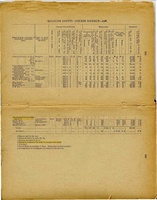
Mine Images
 These files may not be true to scale and are not georgistered. These files may not be true to scale and are not georgistered.
|
Map Type:
|
Federal Land Bank Report
|
| Map ID:
|
Macoupin County
|
| Company:
|
|
| Mine Name:
|
|
| Caption:
|
|
| Map Date:
|
4-1934
|
| Map Status:
|
Secondary
|
| Image Credit:
|
|
| Note:
|
Clipped version of the Federal Land Bank Report.
Full Federal Land Bank (Quade) Download
|
| More Info:
|
Hettick quade
|
| Full Res Download:These files are true to scale and most are georegistered for gis software. These files may be a very large (>1GB) download!
|
|
Photographs