0933: Difference between revisions
Alan.Myers (talk | contribs) No edit summary |
No edit summary |
||
| (8 intermediate revisions by 3 users not shown) | |||
| Line 1: | Line 1: | ||
{{Sidebar Info Query}} | {{Sidebar Info Query}} | ||
{{Header | {{Header | ||
|checked=Checked OK | |||
|unlocated=No | |unlocated=No | ||
|shown_on_map=Yes | |shown_on_map=Yes | ||
| Line 8: | Line 9: | ||
|mine_type=Underground | |mine_type=Underground | ||
|mined-out-area=8,244 | |mined-out-area=8,244 | ||
|indicated=No | |||
|county1=Montgomery | |county1=Montgomery | ||
|county3=Sangamon | |county3=Sangamon | ||
| Line 14: | Line 16: | ||
|quad2=Divernon | |quad2=Divernon | ||
|quad3=Virden South | |quad3=Virden South | ||
|city1=Virden | |||
|year-start=1974 | |year-start=1974 | ||
|year-end=August 2007 | |year-end=August 2007 | ||
| Line 36: | Line 39: | ||
|Section=23 | |Section=23 | ||
|partsection=SE NE NW | |partsection=SE NE NW | ||
}} | |||
{{Shaft locations | |||
|shaft_type=Air shaft | |||
|County=Macoupin | |||
|Town-Range=12N 5W | |||
|Section=8 | |||
|partsection=NW NE SE | |||
}} | }} | ||
==Geology== | ==Geology== | ||
| Line 51: | Line 61: | ||
|Date=1974-2007 | |Date=1974-2007 | ||
|Production=41,644,282 | |Production=41,644,282 | ||
|Sum=Yes | |||
}} | }} | ||
===Production Notes=== | ===Production Notes=== | ||
| Line 60: | Line 71: | ||
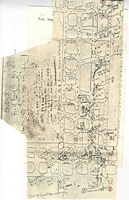
{{Source Map | {{Source Map | ||
|Source Map=Company, Coal Section digital files | |Source Map=Company, Coal Section digital files | ||
|Map Date= | |Map Date=09-04-2007 | ||
|Original Scale=1:12000 | |Original Scale=1:12000 | ||
|Digitized Scale=1:12000 | |Digitized Scale=1:12000 | ||
|Map Type=Final | |Map Type=Final | ||
}} | }} | ||
{{Annotated bibliography header}} | {{Annotated bibliography header}} | ||
| Line 83: | Line 87: | ||
}} | }} | ||
{{Annotated bibliography | {{Annotated bibliography | ||
|bibliography=Company map, Coal Section digital files - | |bibliography=Company map, Coal Section digital files, 6-380_final - Slope and shaft locations, mine outline, mining method. | ||
}} | }} | ||
==Mine Notes== | ==Mine Notes== | ||
| Line 97: | Line 98: | ||
{{Photo Query}} | {{Photo Query}} | ||
= | {{Editwithform}} | ||
{{ | {{#set:IRA=Y}} | ||
{{#set:MSHA_ID=1102236}} | |||
Latest revision as of 15:26, October 19, 2023
Mine Index Number: 0933
| Company Name: | Freeman United Coal Mining Company | ||
|---|---|---|---|
| Mine Name: | Crown II Mine | ||
| Start Date: | 1974 | End Date: | August 2007 |
| Type of Mine: | Underground | ||
| Total acres shown: | 8,244 | ||
| Acres after map date: | General Area of mining acres shown: | ||
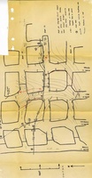
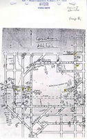
Shaft, Slope, Drift or Tipple Location(s)
| Type | County | Township-Range | Section | Part Section |
|---|
| Shaft | Macoupin | 12N 6W | 23 | NW NE NW |
| Slope | Macoupin | 12N 6W | 23 | SE NE NW |
| Air shaft | Macoupin | 12N 5W | 8 | NW NE SE |
Geology
| Thickness (ft) | |||||
|---|---|---|---|---|---|
| Seam | Depth (ft) | Min | Max | Ave | Mining Method |
Geological Problems Reported
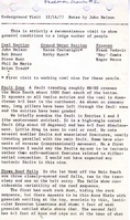
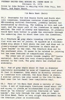
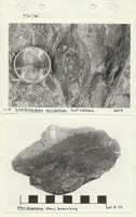
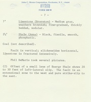
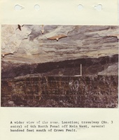
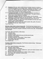
This mine had a variety of problems. There were numerous slickensides, clay dikes, faults and channels throughout the mine. These features, along with a shale roof that lacked competency and allowed for water seepage, created roof problems. Roof falls were reported.
Production
| Company | Mine Name | Date | Production (tons) |
| Freeman United Coal Mining Company | Crown II | 1974-2007 | 41,644,282 |
| Total Production: 41,644,282 | |||
Production Notes
Coal Report production (if available)
Sources of Data
| Source Map | Map Date | Original Scale | Digitized Scale | Map Type |
| Company, Coal Section digital files | 09-04-2007 | 1:12000 | 1:12000 | Final |
Annotated Bibliography (Data source - brief description of information)
| Coal Reports - Production, ownership, years of operation, depth, thickness. |
| Directory of Illinois Coal Mines (Macoupin County) - Mine names, mine index, ownership, years of operation. |
| Mine notes (Macoupin County) - Mine type, shaft location, seam, mining method, geologic problems. |
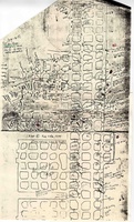
| Company map, Coal Section digital files, 6-380_final - Slope and shaft locations, mine outline, mining method. |
Mine Notes
Mine Images
![[[:Crown II|Crown II]]](https://wikiimage.isgs.illinois.edu/ilmines/macoupin/thumbnails/m0933_final.jpg)
Photographs