Mine Index Number: 2071
| Company Name:
|
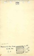
Franklin Coal and Coke Company
|
| Mine Name:
|
Mitchell No. 1 Mine
|
| Start Date:
|
1909
|
End Date:
|
June 1923
|
| Type of Mine:
|
Underground
|
| Total acres shown:
|
129. Recorded production indicates approximately 700 acres were mined, but source map is final. Production from mine index 0057 (Franklin County No. 7 Mine, just east and north of mine index 2071) may have been shipped through the Franklin No. 11 Mine tipple.
|
| Acres after map date:
|
|
General Area of mining acres shown:
|
|
|
|
Shaft, Slope, Drift or Tipple Location(s)
| Type
|
County
|
Township-Range
|
Section
|
Part Section
|
| Main shaft
|
Franklin
|
7S 1E
|
33
|
NW NW SW
|
| Air shaft
|
Franklin
|
7S 1E
|
33
|
NW NW SW
|
Geology
Geological Problems Reported
The mine had gas, and an explosion in 1914 killed 52 men.
Production
| Company
|
Mine Name
|
Date
|
Production (tons)
|
|
|
|
|
|
| Total Production: 6,136,556
|
Production Notes
Coal Report production (if available)
Sources of Data
| Company, 4103.F7 i5.1-6
|
1-6-1948
|
1:4800
|
1:4800
|
Final
|
Annotated Bibliography (Data source - brief description of information)
| Coal Reports - Production, ownership, years of operation, thickness, geologic problems.
|
| Directory of Illinois Coal Mines (Franklin County) - Mine names, mine index, ownership, years of operation.
|
| Mine notes (Franklin County) - Mine type, shaft locations, seam, depth, thickness, ownership.
|
| Company map, ISGS map library, 4103.F7 i5.1-6 - Shaft locations, mine outline, mining method.
|
Mine Notes
Mine Images
![[[:Franklin No. 11|Franklin No. 11]]](https://wikiimage.isgs.illinois.edu/ilmines/franklin/thumbnails/m2071_th.jpg) These files may not be true to scale and are not georgistered. These files may not be true to scale and are not georgistered.
|
Map Type:
|
Company
|
| Map ID:
|
4103.f7 i5.1-6
|
| Company:
|
Franklin Coal and Coke Company
|
| Mine Name:
|
Franklin No. 11
|
| Caption:
|
|
| Map Date:
|
01/06/1948
|
| Map Status:
|
Final
|
| Image Credit:
|
|
| Note:
|
|
| More Info:
|
M2071.jpg
|
| Full Res Download:These files are true to scale and most are georegistered for gis software. These files may be a very large (>1GB) download!
|
https://wikiimage.isgs.illinois.edu/ilmines/franklin/m2071.zip
|
Photographs