Murphysboro Quadrangle
Mining in the Murphysboro Quadrangle
The Murphysboro Quadrangle is the site of the oldest commercial mining in Illinois, the Boon Mine (mine index 7169), which mined coal along the Big Muddy River and rafted it down to New Orleans in seven trips between 1810 and 1812. Other early mines operated here, such as the Jackson County Coal Company mine (mine index 4617), which operated between 1822 and 1865, and the Mt. Carbon Coal Company (mine index 2490), which operated from 1840 to 1850. These mines relied on spring and summer high water on the Big Muddy River to ship their coal, and production was relatively low until more modern railroads were constructed in the 1860s. By 1876, Gartside No. 1 through No. 4 Mine (mine index 0014 and 0266), the Lewis Mine (mine index 0016), and the Mt. Carbon area (Grand Tower Mine, mine index 2490) were all highly productive.
Most of the mining in the Murphysboro Quadrangle was from the Murphysboro Coal. The seam was 6.0 to 7.0 feet thick on the south side of the Big Muddy River, but poor roof conditions prevented extending the mines further eastward. Partings were present in the seam over much of the area, and in some areas on the north side of the Big Muddy River, the partings precluded mining the entire seam. The mines that had particular difficulty with this aspect were the Big Muddy No. 2 Mine (mine index 0012 in 32-T8S-R2W) and Big Muddy No. 10 Mine (mine index 0016 in 20 & 29-T8S-R2W). The coal was present in two or three benches with the parting increasing to 14 feet, so that only one bench could be mined. In one area, a middle bench had a large amount of bone coal, which separated the good upper bench from the good lower bench of coal. This may have prevented westward expansion of the mines. Poor roof conditions were also present in some mines north of the Big Muddy River so that the upper bench or part of the upper bench was left to protect the roof.
In the northeastern portion of the quadrangle, the Herrin Coal was over 6 feet thick and minable by surface or underground methods.
Map and Directory PDF Download
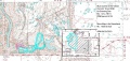
Coal Mines In Illinois Murphysboro Quadrangle
Mines that Appear on the Murphysboro Quadrangle
Unlocated Mines
Jackson County
Pages in category "Murphysboro Quadrangle"
The following 28 pages are in this category, out of 28 total.
Media in category "Murphysboro Quadrangle"
The following 4 files are in this category, out of 4 total.
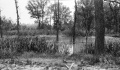 M-1036 Gartside Mine Murphysboro sink low land pillar pulling.jpg 4,376 × 2,561; 1.39 MB
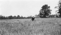 M-979 Sag near Gartside Mine Murphysboro rig in sag.jpg 4,373 × 2,553; 973 KB
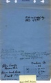 M1020 minenotes.pdf 745 × 1,210, 15 pages; 5.92 MB
 M7811.JPG 812 × 385; 196 KB


