Category:Danville SW-Quadrangle: Difference between revisions
Alan.Myers (talk | contribs) No edit summary |
|||
| (4 intermediate revisions by one other user not shown) | |||
| Line 1: | Line 1: | ||
__NOTOC__ | |||
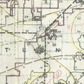
==Mining in the Danville SW Quadrangle== | |||
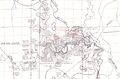
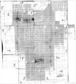
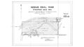
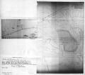
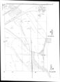
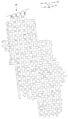
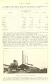
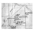
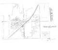
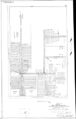
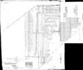
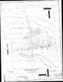
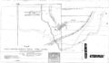
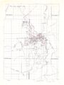
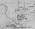
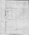
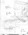
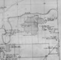
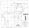
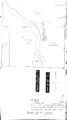
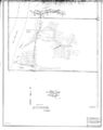
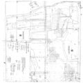
The Danville Coal and Herrin Coal were both mined in the Danville Southeast and Danville Southwest Quadrangles. This location is at the edge of the Illinois Basin and both coals are surface-minable near the Vermilion River. | |||
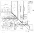
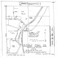
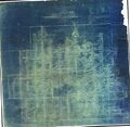
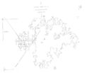
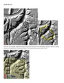
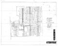
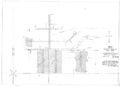
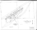
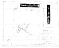
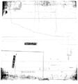
The Danville Coal ranged from 4.75 to over 6 feet thick (thinner where eroded) and the Herrin Coal was generally 5 to 6 feet thick. The depth ranged from very little cover to over 200 feet for the Herrin Coal. The Danville Coal had some geologic problems for mining. Generally, it was closer to the surface, and sometimes water came into the mine. This was aggravated in some circumstances due to channel systems that were contemporaneous with deposition of the upper part of the coal and the roof shales. The channels sometimes cut down into the coal. Horsebacks and rolls were common. | |||
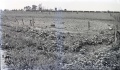
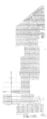
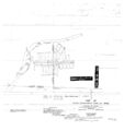
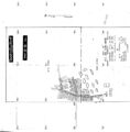
Mining was an important part of the history of Danville since the coal was shallow. The first known mining took place in 1853 by Caruthers & Ball, south of Danville. Most of the early mines were quite small, the more extensive mines not beginning until around 1860. Michael Kelly began surface mining in 1868 along the North Fork but soon moved to Grape Creek and established several mines in that area. Surface mining operations were developed here, the Mission Field west of Danville (sections 19 and 20 of T19N-R12W) being the first site of machine mining with scrapers in 1866 (Kirkland, Blankey & Graves) and later on with the first dragline in 1890. Mining generally slowed significantly in the latter part of World War II, and for the last 30 years only one or two mines operated in Vermilion County. | |||
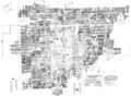
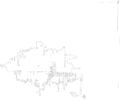
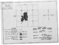
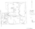
The back of this report includes mines that could not be located due to lack of source maps or locational information in the Coal Section mine notes. Most of these mines are underground and the production indicates approximately 1 square mile in addition to that shown on the map could be undermined. | |||
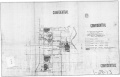
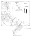
==Map and Directory PDF Download== | ==Map and Directory PDF Download== | ||
[https://wikiimage.isgs.illinois.edu/ilmines/webfiles/topo-mines/danville-sw.pdf Coal Mines In Illinois Danville SW Quadrangle]</br> | |||
[https://wikiimage.isgs.illinois.edu/ilmines/webfiles/ | |||
==Mines that Appear on the Danville SW Quadrangle== | |||
[ | {{#css: | ||
=== | #mw-subcategories {display: none} | ||
#mw-pages {display: none} | |||
{{ | #mw-category-media {display: none} | ||
}} | |||
{{#ask:[[Category:Danville SW-Quadrangle]] | |||
[[:+]] | |||
[[Unlocated::No]] | |||
|?combined = Coal Company, Mine Name | |||
|?County | |||
|format=datatable|limit=1500|link=all|sort=Mine Index|order=asc|headers=plain|mainlabel=Mine Index|searchlabel=... further results|class=sortable wikitable smwtable|sep=<br>|Default='''Mines for this quadrangle have not been entered into Ilmines-Wiki see download above for more information'''}} | |||
==Unlocated Mines== | |||
===Vermilion County=== | |||
{{#ask:[[Category:Vermilion-County]] | |||
[[:+]] | |||
[[Unlocated::Yes]] | |||
|?combined = Coal Company, Mine Name | |||
|?City | |||
|format=datatable|limit=1500|link=all|sort=Mine Index|order=asc|headers=plain|mainlabel=Mine Index|searchlabel=... further results|default=There are no known Unlocated mines in this county |class=sortable wikitable smwtable|sep=<br>}} | |||
{{DISPLAYTITLE:Danville SW Quadrangle}} | |||
Latest revision as of 13:06, January 12, 2024
Mining in the Danville SW Quadrangle
The Danville Coal and Herrin Coal were both mined in the Danville Southeast and Danville Southwest Quadrangles. This location is at the edge of the Illinois Basin and both coals are surface-minable near the Vermilion River.
The Danville Coal ranged from 4.75 to over 6 feet thick (thinner where eroded) and the Herrin Coal was generally 5 to 6 feet thick. The depth ranged from very little cover to over 200 feet for the Herrin Coal. The Danville Coal had some geologic problems for mining. Generally, it was closer to the surface, and sometimes water came into the mine. This was aggravated in some circumstances due to channel systems that were contemporaneous with deposition of the upper part of the coal and the roof shales. The channels sometimes cut down into the coal. Horsebacks and rolls were common.
Mining was an important part of the history of Danville since the coal was shallow. The first known mining took place in 1853 by Caruthers & Ball, south of Danville. Most of the early mines were quite small, the more extensive mines not beginning until around 1860. Michael Kelly began surface mining in 1868 along the North Fork but soon moved to Grape Creek and established several mines in that area. Surface mining operations were developed here, the Mission Field west of Danville (sections 19 and 20 of T19N-R12W) being the first site of machine mining with scrapers in 1866 (Kirkland, Blankey & Graves) and later on with the first dragline in 1890. Mining generally slowed significantly in the latter part of World War II, and for the last 30 years only one or two mines operated in Vermilion County.
The back of this report includes mines that could not be located due to lack of source maps or locational information in the Coal Section mine notes. Most of these mines are underground and the production indicates approximately 1 square mile in addition to that shown on the map could be undermined.
Map and Directory PDF Download
Coal Mines In Illinois Danville SW Quadrangle
Mines that Appear on the Danville SW Quadrangle
Unlocated Mines
Vermilion County
Pages in category "Danville SW-Quadrangle"
The following 200 pages are in this category, out of 678 total.
(previous page) (next page)0
1
- 1830001
- 1830002
- 1830004a
- 1830004b
- 1830005
- 1830006
- 1830007
- 1830008
- 1830009
- 1830010
- 1830014
- 1830016a
- 1830016b
- 1830016c
- 1830017
- 1830018
- 1830019
- 1830022
- 1830023
- 1830025
- 1830026a
- 1830026b
- 1830027a
- 1830028
- 1830029a
- 1830029b
- 1830032
- 1830033
- 1830034
- 1830036
- 1830038
- 1830039a
- 1830040
- 1830041a
- 1830041b
- 1830042a
- 1830042b
- 1830042c
- 1830043a
- 1830043b
- 1830044
- 1830045b
- 1830046
- 1830047a
- 1830047b
- 1830048
- 1830050
- 1830051
- 1830052
- 1830053
- 1830054
- 1830055
- 1830056
- 1830057
- 1830058
- 1830061
- 1830062
- 1830063
- 1830066
- 1830069
- 1830070
- 1830071
- 1830072
- 1830074
- 1830080
- 1830081
- 1830082
- 1830083
- 1830084
- 1830085
- 1830086
- 1830089
- 1830090
- 1830091
- 1830092
- 1830093
- 1830094
- 1830095
- 1830096
- 1830103
- 1830104
- 1830105
- 1830106
- 1830107
- 1830108
- 1830109
- 1830110
- 1830112
- 1830113
- 1830118
- 1830119
- 1830120
- 1830122
- 1830123
- 1830124
- 1830126
- 1830126a
- 1830128
- 1830129
- 1830130
- 1830132
- 1830133
- 1830134
- 1830135
- 1830136
- 1830137
- 1830140
- 1830141
- 1830149
- 1830150
- 1830151
- 1830152
- 1830153
- 1830155
- 1830156
- 1830157
- 1830159
- 1830160
- 1830162
- 1830162a
- 1830164a
- 1830165c
- 1830166a
- 1830166b
- 1830168
- 1830169
- 1830173
- 1830173a
- 1830173b
- 1830174
- 1830175
- 1830176b
- 1830177
- 1830179
- 1830180
- 1830181
- 1830182
- 1830186
- 1830188
- 1830189
- 1830190
- 1830191
- 1830192
- 1830195
- 1830196
- 1830197
- 1830198
- 1830203
- 1830205
- 1830206
- 1830209
- 1830213
- 1830214
- 1830215
- 1830216a
- 1830216b
- 1830216c
- 1830217a
- 1830217b
- 1830221a
- 1830221b
- 1830223
- 1830224
- 1830228
- 1830231
- 1830232
- 1830233
- 1830234
- 1830235
- 1830237
- 1830238
- 1830239
- 1830240
- 1830241
- 1830243
- 1830244
- 1830246
- 1830247
- 1830249
Media in category "Danville SW-Quadrangle"
The following 200 files are in this category, out of 352 total.
(previous page) (next page) 0401 bunsen.jpg 3,390 × 2,267; 334 KB
 Folio67b.jpg 1,919 × 1,256; 1.05 MB
 M-1007 Kelly No 5 Danville District Coop 17 Fig 42 6ft coal 200ft deep.jpg 2,500 × 1,484; 431 KB
 M-1008 Kelly No 5 Danville 6ft coal 200ft deep-ps.jpg 2,500 × 1,480; 545 KB
 M-1009 Kelly No 5 Danville District 6ft coal 200ft deep.jpg 2,500 × 1,461; 500 KB
 M-1010 Kelly No 5 Danville District 6ft coal 200ft deep.jpg 2,500 × 1,478; 573 KB
 M-1011 Kelly No 5 Danville District 6ft coal 200ft deep.jpg 1,454 × 2,500; 438 KB
 M-822 Copp 17 Fig 35 Pit s of Electric Mine Danville District see M-934.jpg 2,500 × 1,469; 579 KB
 M-929 Subsidence Kelly No 5 Mine.jpg 4,408 × 2,666; 1.18 MB
 M-932 Kellyville No 3 near Electric mine Danville District.jpg 4,388 × 2,555; 1.38 MB
 M-933 Kellyville No 3 S of shalft 3ft deep Electric mine Danville District.jpg 2,500 × 1,477; 802 KB
 M-934 Kellyville No 3 near Electric mine Danville District 8ft dia 3ft deep.jpg 2,500 × 1,464; 719 KB
 M-939 Kellyville No 3 near Electric mine Danville District.jpg 2,500 × 1,465; 731 KB
 M0091 minenotes.pdf 739 × 1,193, 40 pages; 10.72 MB
 M0091.jpg 3,390 × 2,535; 2.57 MB
 M0093 coalreport1912 p273.pdf 1,643 × 1,241, 2 pages; 692 KB
 M0093 minenotes.pdf 739 × 1,193, 34 pages; 8.03 MB
 M0093mrg.jpg 3,390 × 2,674; 3.14 MB
 M0094 coalreport1903 p231.pdf 1,547 × 1,231; 284 KB
 M0094 minenotes.pdf 739 × 1,193, 19 pages; 5.06 MB
 M0094 quade.jpg 402 × 441; 61 KB
 M0095 minenotes.pdf 739 × 1,193, 14 pages; 3.47 MB
 M0211 coalreport1903 p231.pdf 1,547 × 1,231; 283 KB
 M0211 coalreport1910 p328.pdf 583 × 943; 86 KB
 M0211 minenotes.pdf 737 × 1,193, 11 pages; 2.5 MB
 M0212 minenotes.pdf 739 × 1,193, 16 pages; 4.53 MB
 M0212 quade.jpg 878 × 877; 182 KB
 M0212.jpg 3,390 × 2,787; 312 KB
 M0400 minenotes.pdf 739 × 1,193, 55 pages; 13.73 MB
 M0400 no7thick.jpg 3,390 × 2,233; 1.08 MB
 M0401 coalreport1914 p171.pdf 1,752 × 1,327; 233 KB
 M0401 minenotes.pdf 739 × 1,193, 20 pages; 5.46 MB
 M0401mrg.jpg 3,076 × 3,390; 3.17 MB
 M0507 minenotes.pdf 739 × 1,193, 13 pages; 3.95 MB
 M0507a.jpg 3,390 × 2,619; 916 KB
 M0507b.jpg 3,390 × 1,433; 305 KB
 M0603 minenotes.pdf 739 × 1,193, 13 pages; 3.55 MB
 M0603.jpg 3,390 × 3,266; 1.35 MB
 M0656 minenotes.pdf 737 × 1,193, 5 pages; 1.42 MB
 M0656.jpg 3,346 × 3,390; 1,023 KB
 M0656b.jpg 3,390 × 1,934; 619 KB
 M0663 minenotes.pdf 737 × 1,193, 6 pages; 1.66 MB
 M0663b ml4103V4 i51-9.jpg 3,390 × 3,028; 1.22 MB
 M0663wrp.jpg 2,495 × 3,390; 723 KB
 M0673 minenotes.pdf 739 × 1,193, 43 pages; 11.23 MB
 M0673.jpg 3,390 × 1,982; 1.26 MB
 M0694 minenotes.pdf 739 × 1,193, 59 pages; 36.11 MB
 M0694 new.jpg 2,342 × 3,390; 1.61 MB
 M0811 minenotes.pdf 739 × 1,189, 22 pages; 5.34 MB
 M0811.jpg 2,862 × 3,390; 1.74 MB
 M0851 minenotes.pdf 739 × 1,189; 332 KB
 M0851.jpg 3,390 × 3,335; 1.49 MB
 M0852 minenotes.pdf 739 × 1,193, 4 pages; 1.12 MB
 M0852.jpg 3,191 × 3,390; 778 KB
 M0853 minenotes.pdf 739 × 1,193, 4 pages; 1.08 MB
 M0889 minenotes.pdf 737 × 1,193, 6 pages; 1.36 MB
 M0924 minenotes.pdf 739 × 1,193, 4 pages; 1.05 MB
 M0924.jpg 3,390 × 3,189; 729 KB
 M0994 minenotes.pdf 737 × 1,193, 78 pages; 46.76 MB
 M0994.jpg 2,514 × 3,390; 741 KB
 M0994a.jpg 1,939 × 3,390; 509 KB
 M1830118 coalreport1899 p80.pdf 1,481 × 1,216; 355 KB
 M1830118 coalreport1900 p139.pdf 1,556 × 1,191; 353 KB
 M2290 minenotes.pdf 739 × 1,189, 4 pages; 1.09 MB
 M3194 minenotes.pdf 737 × 1,193, 3 pages; 701 KB
 M3641 minenotes.pdf 739 × 1,193, 3 pages; 824 KB
 M3641.jpg 3,390 × 2,942; 752 KB
 M3658.jpg 3,390 × 2,512; 324 KB
 M3660 coalreport1910.pdf 583 × 943, 4 pages; 291 KB
 M3660 minenotes.pdf 737 × 1,193, 11 pages; 2.84 MB
 M3661 coalreport1896 p107.pdf 1,610 × 1,210; 300 KB
 M3661 minenotes.pdf 737 × 1,193, 4 pages; 1.11 MB
 M3662 coalreport1895 p55.pdf 750 × 1,185; 128 KB
 M3662 minenotes.pdf 739 × 1,193, 5 pages; 1.39 MB
 M3662 pb363.jpg 3,390 × 2,999; 1.77 MB
 M3663 coalreport1895 p55.pdf 750 × 1,185; 123 KB
 M3663 coalreport1910.pdf 583 × 943, 4 pages; 302 KB
 M3663 minenotes.pdf 737 × 1,193, 10 pages; 2.66 MB
 M3668 coalreport1903 p231.pdf 1,547 × 1,231; 283 KB
 M3668 minenotes.pdf 739 × 1,193, 13 pages; 3.28 MB
 M3668 msha775.jpg 3,390 × 3,297; 3.66 MB
 M3670 coalreport1905 p268.pdf 633 × 977; 126 KB
 M3670 minenotes.pdf 739 × 1,193, 6 pages; 1.64 MB
 M3670.jpg 3,390 × 2,901; 476 KB
 M3673 minenotes.pdf 739 × 1,193, 6 pages; 1.53 MB
 M3673 wpa.jpg 3,390 × 3,125; 1,024 KB
 M3673.jpg 3,112 × 3,390; 766 KB
 M3674 minenotes.pdf 739 × 1,193, 4 pages; 1.16 MB
 M3687 minenotes.pdf 739 × 1,193, 3 pages; 832 KB
 M3688 coalreport1885 p69.pdf 1,656 × 1,300; 904 KB
 M3688 minenotes.pdf 739 × 1,193, 4 pages; 1.08 MB
 M3689 minenotes.pdf 739 × 1,193, 6 pages; 1.6 MB
 M3690 minenotes.pdf 745 × 1,145, 8 pages; 2.85 MB
 M3691 coalreport1884 p508.pdf 1,641 × 1,279; 368 KB
 M3691 coalreport1885 p69.pdf 1,656 × 1,300; 903 KB
 M3691 minenotes.pdf 739 × 1,193, 3 pages; 807 KB
 M3692 mf352930.jpg 3,136 × 2,912; 994 KB
 M3692 wpa 17 19n11w.jpg 540 × 441; 59 KB
 M3694 coalreport1885 p70.pdf 1,656 × 1,300, 2 pages; 1.77 MB
 M3694 coalreport1898 p154.pdf 1,614 × 1,177; 326 KB
 M3694 minenotes.pdf 739 × 1,193, 6 pages; 1.45 MB
 M3694.jpg 3,390 × 2,886; 631 KB
 M3695 lidar.pdf 1,275 × 1,650, 2 pages; 603 KB
 M3695 minenotes.pdf 739 × 1,193, 4 pages; 1.18 MB
 M3696 minenotes.pdf 739 × 1,193, 10 pages; 2.33 MB
 M3698 minenotes.pdf 739 × 1,193, 5 pages; 1.33 MB
 M3699 minenotes.pdf 739 × 1,193, 5 pages; 1.31 MB
 M3700 minenotes.pdf 739 × 1,193, 17 pages; 4.1 MB
 M3701 minenotes.pdf 739 × 1,193, 4 pages; 1.06 MB
 M3702 minenotes.pdf 739 × 1,193, 10 pages; 2.59 MB
 M3703 minenotes.pdf 739 × 1,193, 4 pages; 1.03 MB
 M3704 minenotes.pdf 739 × 1,193, 4 pages; 1.14 MB
 M3704.jpg 2,166 × 3,390; 687 KB
 M3705 fieldnotes.pdf 750 × 1,193; 218 KB
 M3705 minenotes.pdf 739 × 1,193, 8 pages; 2.22 MB
 M3705.jpg 3,390 × 2,845; 1.31 MB
 M3706 minenotes.pdf 739 × 1,193; 173 KB
 M3707 minenotes.pdf 739 × 1,193, 5 pages; 1.28 MB
 M3707.jpg 3,390 × 2,164; 1.07 MB
 M3709 minenotes.pdf 739 × 1,193, 4 pages; 1.11 MB
 M3709.jpg 3,390 × 2,676; 1.13 MB
 M3709b.jpg 3,390 × 2,870; 501 KB
 M3727 minenotes.pdf 739 × 1,193, 4 pages; 1.1 MB
 M3728 minenotes.pdf 739 × 1,193, 9 pages; 2.68 MB
 M3728.jpg 1,336 × 3,390; 934 KB
 M3728b.jpg 3,390 × 2,419; 619 KB
 M3729 coalreport1891 p102.pdf 793 × 1,275; 113 KB
 M3729 coalreport1910.pdf 583 × 943, 3 pages; 221 KB
 M3729 minenotes.pdf 862 × 1,187, 6 pages; 1.45 MB
 M3729 msha1056.jpg 2,357 × 3,390; 2.12 MB
 M3731 coalreport1884 p509.pdf 1,641 × 1,279; 363 KB
 M3731 coalreport1885 p70.pdf 1,652 × 1,293; 919 KB
 M3731 coalreport1898 p153.pdf 1,593 × 1,172; 182 KB
 M3731 minenotes.pdf 739 × 1,193, 4 pages; 1.12 MB
 M3732 minenotes.pdf 739 × 1,193, 4 pages; 1.09 MB
 M3733 coalreport1899 p80.pdf 1,481 × 1,216; 349 KB
 M3733 minenotes.pdf 739 × 1,193, 4 pages; 1.11 MB
 M3734 352910.jpg 3,390 × 2,626; 505 KB
 M3734 minenotes.pdf 739 × 1,193, 4 pages; 1.11 MB
 M3735 minenotes.pdf 739 × 1,193, 4 pages; 1.1 MB
 M3735mrg.jpg 2,617 × 3,390; 1.16 MB
 M3738 minenotes.pdf 739 × 1,193, 4 pages; 1.1 MB
 M3740 minenotes.pdf 739 × 1,193, 4 pages; 1.11 MB
 M3740 msha1050.jpg 3,390 × 2,771; 1.8 MB
 M3748 minenotes.pdf 737 × 1,193, 5 pages; 1.27 MB
 M3749 minenotes.pdf 739 × 1,193, 4 pages; 1.03 MB
 M3749.jpg 3,390 × 1,968; 667 KB
 M3758 minenotes.pdf 737 × 1,193, 27 pages; 6.66 MB
 M3758 no7thick.jpg 2,537 × 3,390; 998 KB
 M3774 minenotes.pdf 737 × 1,193, 5 pages; 1.26 MB
 M3775 minenotes.pdf 739 × 1,193, 4 pages; 1.12 MB
 M3775.jpg 3,390 × 2,776; 808 KB
 M3776 minenotes.pdf 739 × 1,193, 2 pages; 558 KB
 M3776 wpa19n12w.jpg 623 × 517; 74 KB
 M3778 minenotes.pdf 739 × 1,193, 4 pages; 1.18 MB
 M3778.jpg 2,837 × 3,390; 1.15 MB
 M3779 minenotes.pdf 739 × 1,193, 5 pages; 1.38 MB
 M3779.jpg 3,390 × 2,757; 541 KB
 M3780 minenotes.pdf 737 × 1,193, 6 pages; 1.59 MB
 M3780.jpg 3,189 × 3,390; 648 KB
 M3781 minenotes.pdf 739 × 1,193, 4 pages; 1.13 MB
 M3782 minenotes.pdf 739 × 1,193, 4 pages; 1.03 MB
 M3783 minenotes.pdf 739 × 1,193, 5 pages; 1.29 MB
 M3783.jpg 1,470 × 3,390; 729 KB
 M3784 minenotes.pdf 739 × 1,193, 4 pages; 1.12 MB
 M3784.jpg 2,729 × 3,390; 1.28 MB
 M3787 minenotes.pdf 739 × 1,193, 5 pages; 1.27 MB
 M3788 coalreport1907 p249.pdf 587 × 966; 82 KB
 M3788 minenotes.pdf 739 × 1,193, 13 pages; 3.13 MB
 M3788 wpa19n12w.jpg 789 × 769; 123 KB
 M3789 minenotes.pdf 739 × 1,193, 3 pages; 907 KB
 M3790 mf352885.jpg 3,332 × 3,266; 860 KB
 M3793 mf352892.jpg 1,890 × 3,390; 402 KB
 M3793 minenotes.pdf 739 × 1,193, 4 pages; 1.07 MB
 M3793.jpg 2,168 × 3,390; 384 KB
 M3794 minenotes.pdf 739 × 1,193, 4 pages; 1.09 MB
 M3794 wpa19n12w.jpg 540 × 537; 74 KB
 M3795 minenotes.pdf 739 × 1,193, 4 pages; 1.1 MB
 M3796 minenotes.pdf 739 × 1,193, 6 pages; 1.67 MB
 M3796 msha1037.jpg 3,390 × 2,361; 1.82 MB
 M3797 minenotes.pdf 737 × 1,193, 2 pages; 603 KB
 M3797.jpg 3,159 × 3,390; 976 KB
 M3798 minenotes.pdf 737 × 1,193, 4 pages; 1.08 MB
 M3799 352939.jpg 3,044 × 3,102; 620 KB
 M3799 minenotes.pdf 737 × 1,193, 6 pages; 1.54 MB
 M3800 minenotes.pdf 737 × 1,193; 380 KB
 M3801 minenotes.pdf 737 × 1,193, 4 pages; 991 KB
 M3802 mf352946.jpg 2,926 × 3,390; 819 KB
 M3802 minenotes.pdf 737 × 1,193, 4 pages; 981 KB
 M3803 minenotes.pdf 737 × 1,193, 4 pages; 1.03 MB
 M3804 minenotes.pdf 737 × 1,193, 4 pages; 1.15 MB
 M3805 minenotes.pdf 737 × 1,193, 9 pages; 2.41 MB
 M3805.jpg 2,687 × 3,390; 769 KB
 M3806 minenotes.pdf 737 × 1,193, 4 pages; 1.09 MB
 M3807 minenotes.pdf 737 × 1,193, 4 pages; 1,006 KB
 M3808 minenotes.pdf 737 × 1,193, 10 pages; 2.35 MB
 M3809 minenotes.pdf 739 × 1,189, 4 pages; 1.01 MB
 M3809mrg.jpg 3,383 × 3,390; 1.54 MB


