Category:O'Fallon-Quadrangle: Difference between revisions
Alan.Myers (talk | contribs) |
Alan.Myers (talk | contribs) No edit summary |
||
| Line 21: | Line 21: | ||
|?combined = Coal Company, Mine Name | |?combined = Coal Company, Mine Name | ||
|?County | |?County | ||
|format= | |format=datatables|limit=500|link=all|sort=Mine Index|order=asc|headers=plain|mainlabel=Mine Index|searchlabel=... further results|class=sortable wikitable smwtable|sep=<br>|Default='''Mines for this quadrangle have not been entered into Ilmines-Wiki see download above for more information'''}} | ||
==Unlocated Mines== | ==Unlocated Mines== | ||
| Line 31: | Line 31: | ||
|?combined = Coal Company, Mine Name | |?combined = Coal Company, Mine Name | ||
|?City | |?City | ||
|format= | |format=datatables|limit=500|link=all|sort=Mine Index|order=asc|headers=plain|mainlabel=Mine Index|searchlabel=... further results|default=There are no known Unlocated mines in this county |class=sortable wikitable smwtable|sep=<br>}} | ||
Latest revision as of 14:18, October 26, 2022
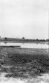
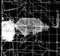
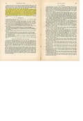
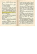
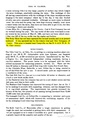
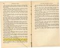
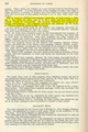
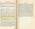
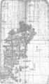
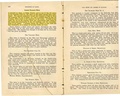
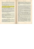
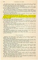
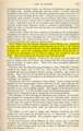
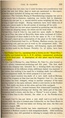
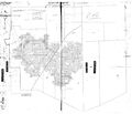
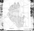
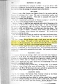
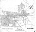
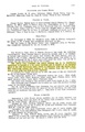
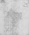
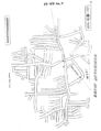
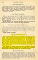
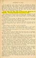
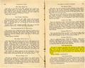
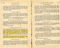
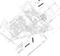
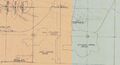
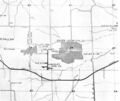
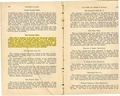
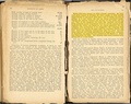
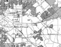
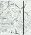
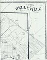
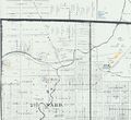
Mining in the O'Fallon Quadrangle
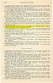
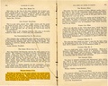
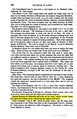
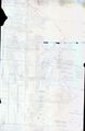
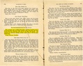
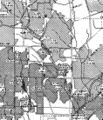
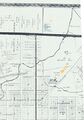
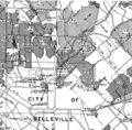
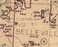
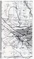
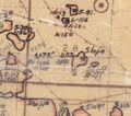
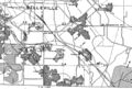
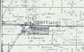
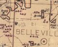
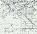
Mining in this quadrangle began prior to 1874, and continued until 1970. The date of the earliest mining is not known; the 1874 Atlas of St. Clair County shows several mines in this area (including mining within Belleville), some with substantial railroad spurs to the mine tipple. The most recent mine in the O'Fallon quadrangle is the Belle Valley Mine (mine index 929), just east of Belleville. Two of the mines in this area operated for long periods; the St. Ellen Mine (mine index 533) was in operation for 56 years and St. Louis & O'Fallon No. 2 (mine index 416) operated for 49 years.
The Herrin Coal was the only coal mined here, ranging from 5.5 to 7.5 feet thick and 40 to 202 feet deep. A number of mines reported problems with the mine floor "heaving" or "squeezing". These problems typically occur in wet conditions such as this where the bedrock cover above the coal is relatively thin.
Note that a number of mines that are known to have operated in this area could not be located. All of this quadrangle contains minable coal and any area is potentially undermined.
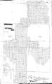
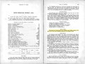
Map and Directory PDF Download
Coal Mines In Illinois O'Fallon Quadrangle
Mines that Appear on the O'Fallon Quadrangle
Unlocated Mines
St. Clair County
Pages in category "O'Fallon-Quadrangle"
The following 126 pages are in this category, out of 126 total.
1
- 1630001
- 1630010
- 1630011
- 1630012
- 1630021
- 1630023
- 1630026
- 1630027
- 1630036
- 1630047
- 1630051
- 1630053
- 1630055
- 1630061
- 1630063
- 1630064
- 1630065
- 1630066
- 1630068
- 1630071
- 1630081
- 1630093
- 1630094
- 1630099
- 1630100
- 1630106
- 1630107
- 1630108
- 1630110
- 1630113
- 1630114
- 1630115
- 1630118
- 1630120
- 1630126
- 1630127
- 1630129
- 1630130
- 1630136
- 1630137
- 1630138
- 1630146
- 1630147
- 1630151
- 1630157
- 1630165
- 1630174
- 1630184
- 1630195
- 1630198
- 1630201
3
9
Media in category "O'Fallon-Quadrangle"
The following 144 files are in this category, out of 144 total.
 M-1035 11 Hippert mine on Freeburg rd freshly filled mine water entering through cave.jpg 2,582 × 4,319; 1.09 MB
 M0079 coalreport1911 p331.pdf 1,660 × 1,239; 300 KB
 M0079 minenotes.pdf 725 × 1,191, 24 pages; 7.1 MB
 M0079 PB986.jpg 3,390 × 2,274; 2.29 MB
 M0079.jpg 1,722 × 1,603; 734 KB
 M0081 IL419421.jpg 3,390 × 2,057; 1.4 MB
 M0081 minenotes.pdf 737 × 1,183, 17 pages; 3.27 MB
 M0081.jpg 3,390 × 2,418; 3.82 MB
 M0201 coalreport1906 p314.pdf 1,670 × 1,270; 418 KB
 M0201 minenotes.pdf 737 × 1,183, 16 pages; 3.6 MB
 M0203 coalreport1904 p316.pdf 1,647 × 1,229; 415 KB
 M0203 minenotes.pdf 725 × 1,191, 35 pages; 8.25 MB
 M0305 coalreport1897 p121.pdf 839 × 1,185; 1.23 MB
 M0305 coalreport1912 p346.pdf 741 × 1,166; 383 KB
 M0305 minenotes.pdf 737 × 1,183, 7 pages; 1.41 MB
 M0341 351103.jpg 2,099 × 3,390; 1.05 MB
 M0341 coalreport1884 p590.pdf 1,612 × 1,289; 293 KB
 M0341 minenotes.pdf 741 × 1,187, 6 pages; 6.23 MB
 M0416 coalreport1904 p316.pdf 779 × 1,172; 522 KB
 M0416 minenotes.pdf 737 × 1,183, 32 pages; 6.6 MB
 M0533 coalreport1903 p292.pdf 1,525 × 1,229; 249 KB
 M0533 coalreport1912 p346.pdf 741 × 1,166; 383 KB
 M0533 minenotes.pdf 737 × 1,183, 12 pages; 5.18 MB
 M0626 coalreport1904 p316.pdf 1,647 × 1,229; 410 KB
 M0626 coalreport1912 p346.pdf 741 × 1,166; 380 KB
 M0626 minenotes.pdf 737 × 1,183, 12 pages; 2.71 MB
 M0626.jpg 3,162 × 3,390; 2.4 MB
 M0781 minenotes newspaper.pdf 1,272 × 1,650, 16 pages; 2 MB
 M0781 minenotes.pdf 733 × 1,183, 10 pages; 4.54 MB
 M0781.jpg 1,971 × 3,390; 2.85 MB
 M0782 351151.jpg 3,390 × 3,351; 861 KB
 M0782 minenotes.pdf 741 × 1,179, 4 pages; 4.75 MB
 M0782.jpg 3,390 × 3,369; 1.57 MB
 M0785 coalreport1884 p570.pdf 1,625 × 1,297; 325 KB
 M0785 coalreport1904 p316.pdf 1,647 × 1,229; 411 KB
 M0785 minenotes.pdf 737 × 1,183, 6 pages; 1.17 MB
 M0785 PB93.jpg 2,743 × 3,390; 1.27 MB
 M0785.jpg 2,608 × 3,390; 4.94 MB
 M0786 351075.jpg 3,390 × 2,637; 377 KB
 M0786 coalreport1884 p570.pdf 1,625 × 1,297; 324 KB
 M0786 coalreport1896 p145.pdf 1,585 × 1,218; 329 KB
 M0786 coalreport1912 p346.pdf 741 × 1,166; 383 KB
 M0786 coalreport1915 p204.pdf 1,560 × 1,275; 334 KB
 M0786 minenotes.pdf 737 × 1,183, 8 pages; 1.56 MB
 M0786.jpg 2,918 × 3,390; 1.63 MB
 M0797 coalreport1900 p187.pdf 745 × 1,177; 384 KB
 M0797 minenotes.pdf 737 × 1,183, 3 pages; 584 KB
 M0929 minenotes.pdf 741 × 1,187, 21 pages; 3.24 MB
 M0929.jpg 3,390 × 2,707; 2.15 MB
 M1630081 coalreport1884 p574.pdf 1,587 × 1,268; 323 KB
 M3488 minenotes.pdf 733 × 1,191, 8 pages; 4.83 MB
 M3488.jpg 2,312 × 3,390; 991 KB
 M3492 coalreport1902 p236.pdf 804 × 1,250; 1.34 MB
 M3492 IL106.jpg 2,195 × 3,390; 1.22 MB
 M3497 atlas1874.jpg 1,143 × 1,977; 624 KB
 M3497 coalreport1884 p574.pdf 1,587 × 1,268; 318 KB
 M3497.jpg 1,608 × 2,181; 283 KB
 M3504 coalreport1900 p188.pdf 741 × 1,143; 382 KB
 M3504 coalreport1901 p239.pdf 639 × 1,168; 307 KB
 M3504 minenotes.pdf 733 × 1,183, 5 pages; 5.18 MB
 M3505 minenotes.pdf 733 × 1,183, 7 pages; 7.39 MB
 M3505.jpg 2,880 × 2,828; 759 KB
 M3506 351053.jpg 5,218 × 4,497; 2.68 MB
 M3506 minenotes.pdf 733 × 1,183, 4 pages; 4.3 MB
 M3507 fieldnotes.pdf 754 × 1,195; 237 KB
 M3507 minenotes.pdf 733 × 1,183, 4 pages; 5.04 MB
 M3509 2020.jpg 3,390 × 3,033; 2.3 MB
 M3509 coalreport1897 p120.pdf 839 × 1,185; 189 KB
 M3509 coalreport1914 p219.pdf 1,754 × 1,327; 220 KB
 M3509 minenotes.pdf 733 × 1,183, 10 pages; 1.54 MB
 M3510 351052.jpg 3,390 × 3,027; 1.79 MB
 M3510 minenotes.pdf 737 × 1,187, 7 pages; 1.09 MB
 M3511 coalreport1905 p325.pdf 633 × 977; 105 KB
 M3511 coalreport1912.pdf 1,641 × 1,241; 307 KB
 M3511 coalreport1916 p219.pdf 654 × 1,016; 64 KB
 M3511 IL21.jpg 2,840 × 3,390; 1.71 MB
 M3511 minenotes.pdf 741 × 1,187, 7 pages; 1.47 MB
 M3512 coalreport1884 p575.pdf 1,587 × 1,268; 325 KB
 M3512.jpg 2,616 × 3,390; 670 KB
 M3513 atlas1874.jpg 1,895 × 1,578; 424 KB
 M3513 coalreport1884 p574.pdf 752 × 1,181; 332 KB
 M3513 minenotes.pdf 741 × 1,187, 3 pages; 3.45 MB
 M3514 coalreport1884.pdf 1,625 × 1,297; 325 KB
 M3514 minenotes.pdf 737 × 1,183, 6 pages; 1.32 MB
 M3514.jpg 2,665 × 3,390; 626 KB
 M3515 coalreport1884 p574.pdf 1,587 × 1,268; 322 KB
 M3516 351022.jpg 939 × 1,098; 597 KB
 M3516 coalreport1889 p70.pdf 700 × 1,143; 399 KB
 M3516 minenotes.pdf 741 × 1,187, 8 pages; 7.66 MB
 M3516.jpg 2,413 × 3,390; 4.04 MB
 M3518 atlas1874.jpg 1,895 × 1,578; 424 KB
 M3518 coalreport1884 p575.pdf 1,587 × 1,268; 323 KB
 M3518 fieldnotes.pdf 747 × 1,193; 177 KB
 M3524 fieldnotes.pdf 747 × 1,193; 177 KB
 M3527 coalreport1884 p574.pdf 1,587 × 1,268; 320 KB
 M3527.jpg 3,390 × 2,838; 299 KB
 M3528 351108.jpg 1,794 × 3,390; 1.1 MB
 M3528 minenotes.pdf 741 × 1,187, 2 pages; 2.53 MB
 M3529 351043.jpg 2,928 × 3,032; 1.01 MB
 M3530 351144.jpg 3,390 × 3,175; 1.51 MB
 M3530 minenotes.pdf 741 × 1,187, 9 pages; 1.22 MB
 M3530.jpg 3,390 × 2,710; 1.4 MB
 M3533 coalreport1912 p346.pdf 741 × 1,166; 383 KB
 M3533 minenotes.pdf 741 × 1,179, 2 pages; 1.94 MB
 M3596 atlas 1874.jpg 3,022 × 4,327; 1.49 MB
 M3596 coalreport1884 p572.pdf 1,587 × 1,272; 335 KB
 M3596.jpg 1,371 × 1,352; 736 KB
 M3598 351137.jpg 3,390 × 1,771; 609 KB
 M3598 minenotes.pdf 737 × 1,183, 5 pages; 1.05 MB
 M3598 PB 207.jpg 3,390 × 1,827; 707 KB
 M3598 wpa 2n7w.jpg 953 × 806; 156 KB
 M3599 350988.jpg 2,587 × 3,390; 445 KB
 M3599 coalreport1884 p570.pdf 1,625 × 1,297; 330 KB
 M3599 coalreport1889 p69.pdf 1,637 × 1,291; 962 KB
 M3599 minenotes.pdf 737 × 1,183, 7 pages; 1.49 MB
 M3604 minenotes.pdf 737 × 1,183, 9 pages; 1.7 MB
 M3626 1950moa.jpg 603 × 491; 87 KB
 M4258 coalreport1889.pdf 1,637 × 1,291, 2 pages; 1.81 MB
 M4258 coalreport1911 p331.pdf 1,660 × 1,239; 304 KB
 M4268 350992.jpg 3,204 × 3,152; 450 KB
 M4289.jpg 2,438 × 3,390; 1.03 MB
 M4290 atlas1874.jpg 1,143 × 1,977; 624 KB
 M4290 MOA1950 Area27.jpg 588 × 518; 85 KB
 M4293 351000.jpg 2,946 × 3,390; 258 KB
 M4294 35099901.jpg 2,582 × 2,275; 358 KB
 M4294 35099902.jpg 2,916 × 2,996; 813 KB
 M4296 coalreport1897 p120.pdf 839 × 1,185, 2 pages; 257 KB
 M4296.jpg 2,780 × 2,232; 345 KB
 M4297 351022 wpa.jpg 1,735 × 1,173; 585 KB
 M4304 MOA1950.jpg 648 × 536; 86 KB
 M4305 atlas 1874 1n-8w a.jpg 1,911 × 1,452; 612 KB
 M4305.jpg 3,056 × 3,390; 702 KB
 M4707 351022.jpg 1,780 × 1,376; 947 KB
 M4707 atlas 1874.jpg 3,040 × 3,390; 1.7 MB
 M4707 coalreport1884 p575.pdf 1,587 × 1,268; 321 KB
 M4731.jpg 3,390 × 2,335; 678 KB
 M4849 atlas 1874.jpg 2,683 × 3,390; 1.38 MB
 M6641 351098.jpg 2,492 × 3,390; 322 KB
 M6641 minenotes.pdf 741 × 1,179, 3 pages; 3.24 MB
 M6642 atlas1874.jpg 3,390 × 3,110; 1.48 MB
 M6663 atlas 1874.jpg 1,842 × 1,154; 324 KB
 M6877 1950moa.jpg 603 × 491; 87 KB
 M6877 atlas1874.jpg 1,143 × 1,977; 624 KB
 M6897 atlas 1874 1n-8w a.jpg 1,764 × 1,613; 496 KB


