Category:Streator South-Quadrangle: Difference between revisions
Alan.Myers (talk | contribs) No edit summary |
Alan.Myers (talk | contribs) No edit summary |
||
| Line 1: | Line 1: | ||
__NOTOC__ | __NOTOC__ | ||
==Mining in the Streator South Quadrangle== | ==Mining in the Streator South Quadrangle== | ||
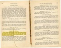
The earliest commercial mining in the Streator South Quadrangle took place along the banks of the | |||
Vermilion River with some early drift mines (mine index [[5907]]) and Francis Murphy’s mine (mine index | |||
[[2346]]) in 1851. By 1876, several mines were established in the south half of Streator, with the Chicago, | |||
Wilmington & Vermilion No. 2 Mine (mine index [[2608]]). According to Paula Angle in Biography in Black, a | |||
History of Streator, Illinois, most of the town of Streator was undermined by 1900. Coal mine operators | |||
continued to mine the Herrin Coal near town and in some instances, extended the shaft deeper to mine | |||
the Colchester Coal. Mining continued in the Streator South Quadrangle until the Streator Clay Pipe Mine | |||
(mine index [[2727]]) closed in 1961. | |||
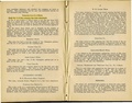
The Herrin Coal was generally between 4.5 and 5.5 feet thick. The Colchester Coal was thinner, between | |||
2.5 and 3 feet, and this coal was mined with the longwall method. The Coal Reports indicated that some | |||
of the mines included in this report did mine the Colchester for up to two years, but no maps of workings in | |||
the Colchester Coal have survived. The areas of these mines fit the size of the polygons shown on the | |||
accompanying map. Therefore, the accuracy of the seam designation in the Coal Reports is uncertain, | |||
since the cost of extending a shaft more than 100 feet further down would have been significant at any | |||
time and mining that coal should have proceeded for more than a couple of years to justify that cost. One | |||
possibility is that slopes or shafts were lowered to the level of the Colchester Coal, but the associated | |||
underclay was the desired product and not the coal. | |||
==Map and Directory PDF Download== | ==Map and Directory PDF Download== | ||
Latest revision as of 08:49, October 28, 2022
Mining in the Streator South Quadrangle
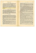
The earliest commercial mining in the Streator South Quadrangle took place along the banks of the Vermilion River with some early drift mines (mine index 5907) and Francis Murphy’s mine (mine index 2346) in 1851. By 1876, several mines were established in the south half of Streator, with the Chicago, Wilmington & Vermilion No. 2 Mine (mine index 2608). According to Paula Angle in Biography in Black, a History of Streator, Illinois, most of the town of Streator was undermined by 1900. Coal mine operators continued to mine the Herrin Coal near town and in some instances, extended the shaft deeper to mine the Colchester Coal. Mining continued in the Streator South Quadrangle until the Streator Clay Pipe Mine (mine index 2727) closed in 1961.
The Herrin Coal was generally between 4.5 and 5.5 feet thick. The Colchester Coal was thinner, between 2.5 and 3 feet, and this coal was mined with the longwall method. The Coal Reports indicated that some of the mines included in this report did mine the Colchester for up to two years, but no maps of workings in the Colchester Coal have survived. The areas of these mines fit the size of the polygons shown on the accompanying map. Therefore, the accuracy of the seam designation in the Coal Reports is uncertain, since the cost of extending a shaft more than 100 feet further down would have been significant at any time and mining that coal should have proceeded for more than a couple of years to justify that cost. One possibility is that slopes or shafts were lowered to the level of the Colchester Coal, but the associated underclay was the desired product and not the coal.
Map and Directory PDF Download
Coal Mines In Illinois Streator South Quadrangle
Mines that Appear on the Streator South Quadrangle
Unlocated Mines
Livingston County
La Salle County
Pages in category "Streator South-Quadrangle"
The following 116 pages are in this category, out of 116 total.
0
2
3
5
6
Media in category "Streator South-Quadrangle"
The following 50 files are in this category, out of 50 total.
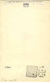
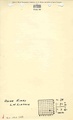
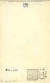
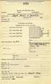
 M0754 minenotes.pdf 733 × 1,204, 6 pages; 1.62 MB
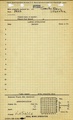
 M2074 coalreport1884.pdf 1,639 × 1,287; 294 KB
 M2074 coalreport1885.pdf 1,656 × 1,300; 784 KB
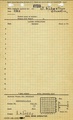
 M2074 minenotes.pdf 731 × 1,202, 2 pages; 383 KB
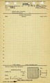
 M2608 minenotes.pdf 731 × 1,202, 2 pages; 357 KB
 M2609 coalreport1891.pdf 793 × 1,275, 2 pages; 214 KB
 M2609 minenotes.pdf 731 × 1,202, 2 pages; 361 KB
 M2612 minenotes.pdf 731 × 1,202, 3 pages; 656 KB
 M2613 minenotes.pdf 731 × 1,202, 4 pages; 714 KB
 M2618 coalreport1906 p164.pdf 1,675 × 1,256; 448 KB
 M2618 minenotes.pdf 731 × 1,202, 3 pages; 578 KB
 M2619 minenotes.pdf 731 × 1,202, 2 pages; 343 KB
 M2620 minenotes.pdf 731 × 1,202, 2 pages; 368 KB
 M2622 minenotes.pdf 731 × 1,202, 2 pages; 373 KB
 M2623 minenotes.pdf 731 × 1,202, 2 pages; 366 KB
 M2625 fieldnotes.pdf 752 × 1,187; 284 KB
 M2625 minenotes.pdf 731 × 1,202, 2 pages; 358 KB
 M2626 minenotes.pdf 731 × 1,202, 3 pages; 613 KB
 M2627 minenotes.pdf 731 × 1,202, 4 pages; 825 KB
 M2628 minenotes.pdf 731 × 1,202, 2 pages; 350 KB
 M2629 minenotes.pdf 731 × 1,202, 2 pages; 359 KB
 M2630 coalreport1885.pdf 1,656 × 1,300, 2 pages; 1.55 MB
 M2630 minenotes.pdf 731 × 1,202, 2 pages; 358 KB
 M2632 fieldnotes.pdf 745 × 1,193; 229 KB
 M2632 minenotes.pdf 731 × 1,202, 5 pages; 1.04 MB
 M2633 coalreport1884.pdf 1,639 × 1,287; 302 KB
 M2633 coalreport1885.pdf 1,658 × 1,304; 813 KB
 M2633 minenotes.pdf 731 × 1,202, 2 pages; 370 KB
 M2634 coalreport1884.pdf 1,639 × 1,287; 301 KB
 M2634 coalreport1885.pdf 1,658 × 1,304; 809 KB
 M2634 minenotes.pdf 731 × 1,202, 2 pages; 373 KB
 M2640 minenotes.pdf 731 × 1,202; 276 KB
 M2644 minenotes.pdf 733 × 1,204, 7 pages; 1.68 MB
 M2646 coalreport1891.pdf 793 × 1,275; 168 KB
 M2646 minenotes.pdf 733 × 1,204, 5 pages; 1.16 MB
 M2647 minenotes.pdf 733 × 1,204, 2 pages; 378 KB
 M2648 minenotes.pdf 733 × 1,204, 2 pages; 363 KB
 M5544 minenotes.pdf 731 × 1,202, 2 pages; 520 KB
 M5671 minenotes.pdf 731 × 1,202; 258 KB
 M5677 minenotes.pdf 731 × 1,202; 228 KB
 M5707 minenotes.pdf 731 × 1,202; 268 KB
 M90992610 minenotes.pdf 731 × 1,202, 3 pages; 608 KB
 M90992685 minenotes.pdf 731 × 1,202, 3 pages; 571 KB
 M90995662 minenotes.pdf 731 × 1,202, 2 pages; 546 KB
 M90995665 minenotes.pdf 731 × 1,202; 221 KB
 M90995666 minenotes.pdf 731 × 1,202; 267 KB
 M90995668 minenotes.pdf 731 × 1,202; 272 KB
 M90995669 minenotes.pdf 731 × 1,202; 264 KB
 M90995670 minenotes.pdf 731 × 1,202; 259 KB
 M90995672 minenotes.pdf 731 × 1,202; 259 KB